THE YORKSHIRE DALES GREEN LANES ALLIANCECampaigning to free green lanes from recreational vehicles. Where the tarmac stops, vehicles should stop. YDGLA, PO Box 159, Otley, LS21 9BTEmail: ydgla@europe.com
Home |
The area and its problems |
Solutions |
How the YDGLA campaigns
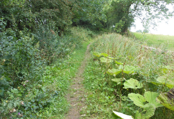
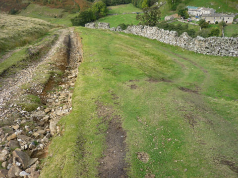
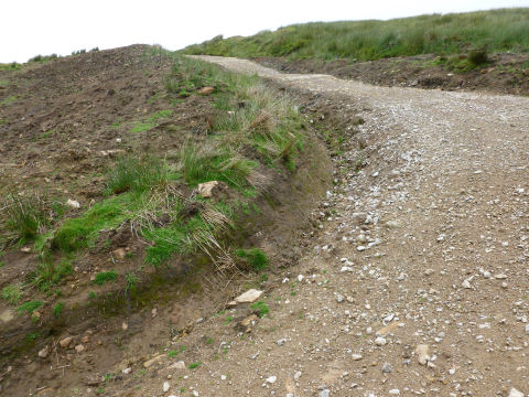
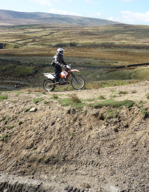
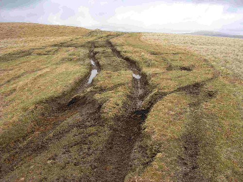
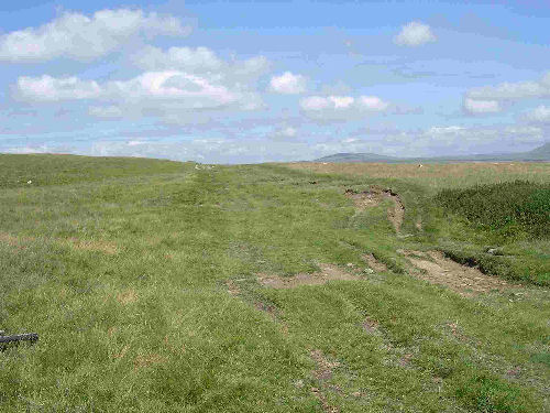
Latest NewsOFF-ROADERS IN ACTION Posted June 2025 GLEAM, the national umbrella organisation for all organisations and individuals who want to see an end to off-roading, has published on its website footage of the activities of motorbikes and 4x4s on green lanes. The footage has been gathered from YouTube and shows off-roaders enjoying themselves in national parks, national landscapes (formerly known as Areas of Outstanding Natural Beauty) and in other parts of England and Wales. Nearly all the clips were proudly posted by off-roaders themselves. There are hardly any examples of filming by their opponents. What is striking is that off-roaders in these examples are keen to exhibit the damage that they are inflicting on the green lanes (and sometimes on private land adjacent to the lanes), or are entirely indifferent to it. There is not the slightest recognition of the impact that their fun makes. These examples - and there are dozens more on YouTube (just search for 'green-laning') - show the stark opposition between, on one hand, green lane users who either need them for their agricultural work, or who seek quiet, peaceful recreation on the wonderful network, and, on the other, those who delight in the challenge of taking noisy, destructive, motorbikes and 4x4s along the muddiest, wettest, rockiest, rutted tracks that they can find, or on stretches of moorland where there is no track at all, leaving them, in most cases, unusable by anybody else. See for yourself by following this link: https://www.gleam-uk.org/videos/ THWAITE LANE FINALLY FREED FROM OFF-ROADERS Posted December 2025 Thwaite Lane is the beautiful green lane that runs from just north-east of Austwick, to Clapham, which it approaches through the tunnels close to Clapham church. Thwaite Lane was one of the very first green lanes to be championed by YDGLA, back in 2002. The Trail Riders Fellowship (TRF), representing motorbikers, made an application for Thwaite Lane to be upgraded from bridleway to byway open to all traffic (BOAT) in 2004, which resulted in the Yorkshire Dales National Park Authority making a BOAT order for most of the lane in 2007. However the National Park Authority changed their mind, following the Winchester judgment in 2008, and decided that the whole route should be a restricted byway, i.e. not open to recreational motorised users. This decision, and objections to the order, meant that the order and objections had to be referred to the Planning Inspectorate for determination. Thwaite Lane has finally been determined, following written representations in 2024 and a public inquiry in 2025, to be a restricted byway throughout We must thank Austwick Parish Council for pressing for Thwaite Lane to be given a higher priority on the list of cases that needed determining by the Planning Inspectorate. We must also thank both Austwick and Clapham parish councils, and many local individuals and organisations for their opposition to the 2007 BOAT order. Getting 4x4s and motorbikes legally excluded from Thwaite Lane has been a long-drawn out business, but the eventual result is cause for celebration. Public inquiries are customarily held at venues close to the disputed right of way, but North Yorkshire Council chose to hold the two-day inquiry at County Hall, in Northallerton. This put the Austwick and Clapham parish councillors, and other local people, who objected to the order, at a disadvantage, for there is no public transport to Northallerton, and although there were video links, they were not nearly as effective as attendance in person. Unsurprisingly, the Green Lane Association (GLASS), representing off-roaders, argued strenuously at the inquiry that Thwaite Lane should be a BOAT, and that North Yorkshire Council and the National Park Authority were wrong in saying that it should be a restricted byway, as a result of the Winchester judgment. Surprisingly, though, the case for BOAT status rather than restricted byway, i.e. that the Winchester judgment did not apply, had already been made by the British Horse Society (BHS) in their written representations in 2024. Inexplicably, the BHS had promoted an argument later adopted by the off-roaders. One would think that the natural home for equestrians, who all want better and safer conditions for their activities, would be with groups, such as YDGLA, or the Green Lanes Environmental Action Movement (GLEAM), that campaign against recreational motor traffic on green lanes and on other routes that could be made traffic-free. But not so. In her findings, the Inspector ruled that the evidence of historic vehicular rights arising from historic use by horse-drawn vehicles, outweighed YDGLA's argument that Thwaite Lane should remain a bridleway. However, she was not persuaded by GLASS's argument that the Winchester judgment did not apply to the TRF application and it was therefore exempt from the Natural Environment and Rural Communities Act (NERCA), i.e. that historic horse-drawn vehicular rights on Thwaite Lane confer modern motor vehicular rights. The Inspector agreed with YDGLA's and Austwick Parish Council's arguments that the exemption from NERCA claimed by GLASS did not apply. Rather, she ruled, motor vehicular rights were extinguished, in 2006, by NERCA, following the Winchester Judgment in 2008. This judgment established that applications for motor vehicular rights on existing footpaths and bridleways such as Thwaite Lane must be made in a way that conforms strictly to the legal requirements e.g. including all the evidence on which the applicant relies. And the application for Thwaite Lane that had been submitted by the motorcyclists' group, the Trail Riders Fellowship back in September 2004, and which was vigorously supported by GLASS at the inquiry in 2025 and supported by the BHS in 2024, was deficient. To repeat, the Inspector's conclusion is that Thwaite Lane is a restricted byway. Phew. The public inquiry into Thwaite Lane, although highly technical, does demonstrate that a solid foundation, put into place first by NERCA, and then strengthened by the Winchester Judgment, is now well-established. This foundation was supported by YDGLA and several other like-minded groups that continue to save precious lanes, across England and Wales, and protect them forever as places for peaceful enjoyment by all users, free from the damage and disturbance caused by recreational 4x4s and motorbikes. To conclude with a general point about off-roading and green lanes, it cannot be repeated too often that closing green lanes to off-roading excludes nobody from the enjoyment of these wonderful lanes. All that is required is that motor vehicles (apart from agricultural vehicles) are left where the tarmac stops, and that people put on their walking boots, or get on their bicycles, or mount their horses, or set off on their mobility scooters, all to enjoy the unique pleasures opened up by green lanes. Green lanes are for everybody - but not for 4x4s and motorbikes. A TRO on a route that crosses Ilkley MoorPosted December 2023 Ilkley Moor is emblematic: it has been, for hundreds of years, a place where people from the surrounding industrial towns - Keighley, Leeds, Bradford - as well, of course, from Ilkley itself, have gone for peace and quiet and to enjoy the natural world of heather, rocks and moorland birds. There is, however, one route across the moor that probably has rights for motor vehicles, deriving from its historic status as a horse-and-cart route. A mile or so of this track remains unsealed by tarmac, and has been used by 4x4 and motorbike drivers, some of whom drive off the route onto the surrounding moorland. The track is known as 'Keighley Road' and runs from the aerials at Whetstone Gate, northward across the moor, to descend towards Ilkley, near Silver Well Cottage. The good news is that Bradford Council is proposing to impose a traffic regulation order on the track, prohibiting non-essential motors. A public consultation on the proposed order ends on January 5th, with responses in support to be sent to legalobjections@bradford.gov.uk (quoting ref. CORP/PCD/DS/415488). Details of the order itself and a map of the route may be found at https://bradford.moderngov.co.uk/mgConsultationDisplay.aspx?ID=634 Feeble outcome to DEFRA's public consultation on the Glover Landscapes Review Posted December 2023 After a lengthy delay, DEFRA has finally published its response to this consultation. The consultation was important for us, for it contained a few questions where the public, and interested bodies, were asked for their views on the desirability or otherwise, of restricting, or prohibiting, the use of non-essential vehicles on green lanes. While we were waiting for the government's formal response, the minister told us that no new legislation is envisaged: so, whatever the response to the consultation, we could not expect the government to commit itself to making major changes. However, when the government's formal response was eventually published, it did contain three positive features. One feature may sound rather trivial, but could prove to be very important. Until the consultation, arguments about green lanes have used the concepts of 'sustainable' and 'unsustainable' when considering whether non-essential vehicles should be allowed to use green lanes. But DEFRA has now replaced the concept of 'sustainability' with the concept of 'suitability'. What's the difference? 'Sustainability' focuses attention on the surface of the lane: is the surface capable of carrying, or can it be modified to carry, 4x4s and motorbikes? The problems with this approach is that, if sufficient money is spent, any track can be made to withstand the passage of motor vehicles, even if the result is that the character of the green lane is transformed. (Deadman's Hill, in Nidderdale, is a case in point.) But the concept of 'suitability' opens up the debate to quite different considerations. Is the track in a national park? Is it a national trail? Does it pass through areas of great scientific or historic interest? What do local residents think? Is it particularly valued by walkers, cyclists, equestrians and disabled people? The difference, therefore, between 'sustainable; and 'suitable' is not trivial: it could be decisive. The second feature of the government's response opens up tricky questions. Who is to decide which green lanes are suitable, and which are not? And remember that there are over 7,000 miles of them. Plainly, DEFRA cannot manage the job from Westminster: it will have to be done by local and national park authorities, and, equally plainly, they are under-resourced. No doubt the vehicle user groups will spring forward, saying 'Leave it to us. Our members will do it.' Equally, groups like ours, parish councils, and multitudes of amenity groups will be keen to assess the suitability of the green lanes that they know well. What off-roaders consider to be suitable routes for their activities, and what everybody else thinks will not coincide. We are waiting for details of the procedures that will classify green lanes into suitable and unsuitable. The third feature of the government's response is a commitment to revise the guidance that local authorities are given for the imposition of traffic regulation orders. At present, the system is cumbersome, expensive, time-consuming and unbalanced - as between those who want TROs and those who object to them. A working group has been set up to advise the government, but it appears to have made little, or no progress so far. New publication from GLEAM Posted December 2023 The Green Lanes Environmental Action Movement (GLEAM) is the national umbrella organization speaking on all green lane matters. Its website (http://www.gleam-uk.org) is full of up-to-date information on the state of play, nationally and locally. But GLEAM has, until now, lacked a single document that sets out the case for bringing off-roading to an end. The document, entitled Calling time on off-roading, may be found on GLEAM's website at http://www.gleam-uk.org/news/calling-time-on-off-roading/ The document is comprehensive, well-illustrated and well-argued. It will become the standard reference point for the case for bringing off-roading to its long-overdue end. An opportunity to bring recreational vehicle use of green lanes to an end. Posted 23 February 2022 For YDGLA, the Glover Landscapes Review was a bit disappointing, for it didn't directly address the question of the impact of recreational motor vehicles on green lanes - ie unsealed byways open to all traffic (BOATs) and unsealed unclassified roads (UURs), in national parks and areas of outstanding natural beauty (AONBs). DEFRA, the government department charged with the job of responding to Glover, took its time, but has recently issued its response. We are very pleased to say that the report, and the accompanying public consultation, include questions about the very issues that brought YDGLA into existence, 20 years ago. Question 14 in the public consultation asks whether national park and local highway authorities should be given 'additional powers to restrict recreational motor vehicle use on unsealed routes?' and asks respondents to give their reasons. These bodies already have the power to impose traffic regulation orders (TROS), but these orders are infrequently imposed, for they are cumbersome, expensive, time-consuming, and are usually challenged by vehicle users. The answer to the question, therefore, is 'yes': additional powers are needed, for the simple reason that, at present, effective TROs are too difficult for authorities to impose. Question 15 asks you to give reasons why authorities should exercise these additional powers. 'Environmental protection', 'prevention of damage', 'nuisance', 'amenity' and 'other (please state)' are suggested. The first four reasons cover many of the impacts of recreational motor vehicles on green lanes, but you may have further reasons to specify in 'other'. These 2 questions (14 & 15) are about legislation that would help authorities to restrict vehicle use, lane by lane. This would certainly be helpful, but it is by no means the best solution. Question 16, however, opens up the prospect of all the green lanes in our area that are UURs being closed by means of a change in the law, Question 16 asks 'Should we legislate to restrict the use of motor vehicles on unsealed unclassified roads for recreational use, subject to appropriate exemptions?' YDGLA members and supporters will have no hesitation in ticking the box 'Yes - everywhere'. This is the legislation that will close the loophole in the NERC Act 2006, a loophole that allows historic horse-and-cart use of unsealed unclassified roads by the public to confer the right for motorcyclists, quad-bikers and 4x4 drivers to drive these green lanes, with all the consequent impacts on the lanes themselves, and on other users. This is exactly what we have been campaigning for since 2013. It is very encouraging that the government has at last put the question to the public - although it's somewhat discouraging that the question refers only to UURs, and not to BOATs. Question 17 asks what exemptions would be needed in this legislation for other users e.g. residents and businesses. The exemptions provided for motorised users of the green lanes protected by the NERC Act 2006, i.e. for residents and other land owners/occupiers, for their visitors and for users of invalid carriages e.g. powered mobility scooters, have worked, so it would be appropriate and effective to have similar exemptions in new legislation. The government's response and the public consultation can be found at: Belford Lane, Dallowgill. This beautiful lane, as we reported, was so badly-damaged that a temporary TRO was imposed while it was repaired. With the repairs completed, NYCC were evidently satisfied that the TRO could be lifted. Immediately, vehicle users resumed their activities. A 4x4 got itself stuck in one of the fords. The police, the fire brigade, and even the air ambulance were called. You can find the full story at https://thestrayferret.co.uk/firefighters-rescue-passengers-from-car-stuck-in-dallowgill-ford/ Posted 19 October 2021 The climate crisis and the Covid lockdowns have brought two truths home to us all. First, our carbon footprint must be reduced: we must not use our cars and motorbikes when walking or cycling is an alternative. Second, the lockdowns have shown us how much people need, and value, tranquil countryside, far away from the noise, pollution and damage associated with motor vehicles. YDGLA's project is even more necessary than it was when we started, back in 2002. 1. Gayle Lane In former newsletters we have reported on the fate of this very attractive, short green lane in the hamlet of Braythorn, near Otley, just outside the Nidderdale Area of Outstanding Natural Beauty. Gayle Lane was so badly damaged by 4x4 and motorbike users that it became difficult for horse-riders, cyclists and walkers to make their way along it, especially on the steep sections. North Yorkshire County Council (NYCC) recognized that the lane was in a bad way and applied its now familiar policy of 'close, repair, re-open.' A temporary, 18 month, traffic regulation order (TRO) was imposed, and repairs were made. The lane now looks lovely. (see illustration)
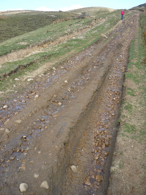
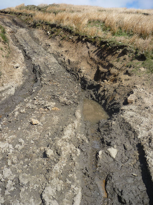
However, in line with NYCC's policy, the TRO has expired, and the lane has been re-opened to 4x4s and motorbikes. It will be interesting to see for how long Gayle Lane will survive in its present, excellent condition. The examples of other green lanes that have been re-opened to recreational vehicles after repairs is not encouraging. 2. Deadman's Hill This wonderful route, connecting Nidderdale and Coverdale, has made an appearance in virtually every YDGLA newsletter, stretching back to 2002. It is a salutary example of the futility of the policy of 'close, repair, re-open'. During the past 20 years, NYCC have imposed temporary TROs and made numbers of attempts to repair the route. 4x4 and motorbike user groups have also, voluntarily, attempted repairs. What has been the result? It is instructive to compare an illustration of what Deadman's looked like 20 years ago, with illustrations of its present state.
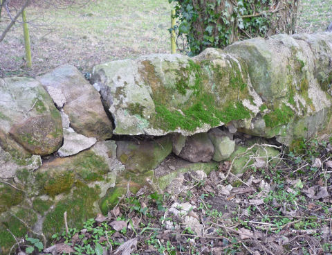
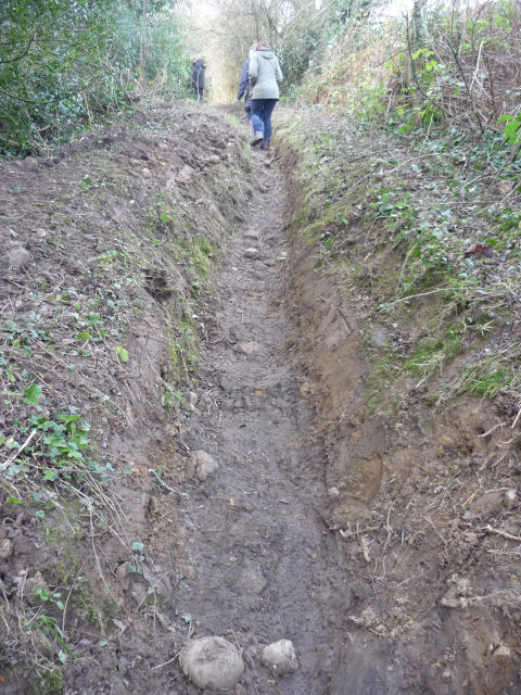
The short section illustrated in the first picture is a footpath. It is the surviving stretch of the track that was submerged when the reservoir was constructed. It was dedicated as a footpath in 1997. The route used by 4x4s and motorbikes turns away from this footpath at Lodge. Thus, the footpath has escaped the damage inflicted on the rest of the route and remains as a poignant reminder of what might have been if a TRO had been imposed, years ago. By contrast, the long section that is open to recreational vehicles has been degraded throughout its length. So desperate have attempts been to keep it navigable for vehicles, that concrete has been used near the summit in the hope that cross-drains can be made to work. It's a mess. In the steep sections, the surface of rocks is so loose that they are sliding inexorably downhill, making progress on foot, on a mountain bike, or on a horse, both up and downhill, difficult and disagreeable. Deadman's connects, to the south, with In Moor Lane, which terminates in Middlesmoor. Together, the 2 routes measure 6.5 miles (10.5 kms). A freedom of information request to NYCC yielded the following: between 2017 and 2021, repairs, paid from the public purse, cost £76,280 - ie nearly £12,000 a mile. Was this a good use of public money? And is there any end in sight of the need for more, and yet more money to be spent on trying to keep the route open to non-essential vehicles, when the general public would prefer to see such vehicles prohibited? Is there any prospect of NYCC revising its 'close, repair, re-open' policy? No, to all three. But we keep pushing. 3. Blubberhouses Moor Another regular in YDGLA newsletters, but this time there is some promising news. There are nearly 17 miles (27kms) of routes criss-crossing this superb moor and adjacent land. Most of them are entirely invisible on the ground, but they are entered on NYCC's list of streets maintainable at public expense as Unclassified Unsealed Roads (UURs). As the name suggests, the public rights on these routes, beyond the rights of pedestrians, is unknown. When YDGLA was founded, back in 2002, large sections of the blanket peat sections of Blubberhouses Moor had been ruined by recreational vehicles - mostly motorbikes - in some places irreparably. A zonal TRO was eventually imposed across the whole moor. With the prospect of the expiry of the TRO, YDGLA members conducted a thorough survey of every inch of the network and submitted it to NYCC. At the same time, the history of the network was investigated. It turns out that nearly all the tracks across the moor are, historically, either footpaths or pack-horse routes. It will take some time before this research is ratified by NYCC's rights of way team, but there is now a real prospect that the 17 miles of routes on the moor will be entered on the Definitive Map (and then on Ordnance Survey maps) as footpaths and bridleways. It's been a long haul, but the prospect of a vehicle-free Blubberhouses is just over the horizon. 4. Belford Lane As we reported in the last newsletter, the ruinous state of this green lane, near Kirby Malzeard, and on the Ripon Rowel trail, has finally prompted NYCC to impose a temporary TRO and to undertake repairs - which will be very expensive because extensive drainage will be required. As usual, the TRO is only temporary. Recreational vehicles will be re-admitted at the expiry of the order. Quite a few vehicle users are, in any case, ignoring the TRO and are continuing to drive and ride along the lane. The attractions of tackling fords and flooded tracks are, it seems, hard to resist. 5. Developments in the Lake District YDGLA's partner group, the Lake District Green Lanes Alliance (ldgla.org.uk) is battling on to challenge what appears to be an unhealthily cosy relationship between the National Park Authority and vehicle user groups. For example, a consultative group was set up by the Authority to come up with a management plan for green lanes in Little Langdale. Surprise, surprise. The composition of the group gives a hefty preponderance to vehicle users. Even the representative of disabled users is a vehicle user. Undaunted, LDGLA members are gathering scientifically-reputable evidence of the impact of recreational vehicles on the fragile ecology of the terrain bordering the green lanes, and the lanes themselves. 6. What needs to be done, locally and nationally? Locally, NYCC and the Dales National Park Authority have powers to impose TROs. If authorities are determined to impose them, TROs could be imposed on all the damaged, vulnerable lanes. However, some authorities are so unsure of the fine detail of the regulations governing TRO-making, that they yield to threats of litigation issued by vehicle user groups. Rather than risk being taken to the High Court, Authorities will back off and do nothing. The Yorkshire Dales National Park Authority is an exception. When it was devising its programme for the imposition of ten TROs, it carefully did its legal homework. Yet it still fell foul of a High Court challenge from vehicle users, on a technicality. Undaunted, the Authority re-made its orders, in compliance with the Court's ruling. The ten TRO orders were then litigation-proof and are still in place and are an outstanding success in protecting the green lanes covered by the orders. But it is clear that complete answers to the blight of non-essential vehicles on green lanes will come not from local authorities, but from Parliament. The law must be changed. First, and fairly easily-accomplished, would be a simplification of the procedures for imposing TROs. Additional grounds for imposing TROs - for example, to give explicit consideration to the amenity of non-motorised users - would be welcome, as would a streamlining of the procedures governing public consultations. But secondly, Parliament must remove the rights of non-essential motor vehicle users to drive on unsealed ways - ie green lanes. It could do this in one of two ways, either of which would have the desired effect. It could simply re-classify UURs and unsealed byways, en bloc, as Restricted Byways (which, by definition, have no rights for non-essential motors). Or it could declare that whatever rights the 3000 miles UURs turn out to bear, these rights will not include the right to take non-essential motor vehicles along them. We'll let you know when Parliament legislates and it's time for YDGLA to break out the champagne and wind itself up. Campaign to save two green lanes in Little Langdale, in the Lake District Posted 18 December 2019 YDGLA's official territory is the Dales National Park and the Nidderdale Area of Outstanding Natural Beauty, but we have given full support to campaigners in the Lake District who are trying to save two green lanes near Tilberthwaite in Little Langdale, from what they see, rightly we think, as wholly inappropriate use by motorbikes and 4x4s, including large numbers of 4x4s operated by commercial companies, and vehicles that come from countries on the continent that tend to outlaw non-essential vehicles from their own national parks. The landscape across which the lanes run, and the farms sited there, were bequeathed to the National Trust by Beatrix Potter. The writer of the famous walkers' guides, Alfred Wainwright, called this area of Lakeland one of the most beautiful in the region. Campaigners, and supporters from up and down the country, including the National Trust and the Friends of the Lake District, were appalled when, at a meeting of the National Park Authority's Rights of Way Committee in October this year, a decision was taken to leave the lanes open to recreational vehicles. This extraordinary decision has led to a legal action for judicial review against the Authority, on grounds of a failure to discharge its statutory obligation to protect and enhance the landscapes in its care. The judicial review is being brought by the Green Lanes Environmental Action Movement (GLEAM). Judicial reviews are extremely expensive affairs, and so to cover the legal costs, a crowd-funding website has been set up. It has got off to a flying start: people really do care about protecting precious landscapes from non-essential 4x4s and motorbikes. But there is a long way to go. You are encouraged to visit the crowd-finding site, read a few of the heart-warming comments that have been left by contributors, find out more about the issue by following the links, and above all, give what you can to show your commitment to the cause of vehicle-free green lanes. https://www.crowdjustice.com/case/green-lanes-environmental-action/ Blubberhouse Moor - again Posted 18 December 2019 The vast and beautiful moor located south of the A59 between Blubberhouses Church and Bolton Bridge has been one of YDGLA's enduring concerns, ever since we were formed, back in 2002. The moor is within the Nidderdale Area of Outstanding Natural Beauty, is designated a Site of Special Scientific Interest, is a Special Area of Conservation, and a Special Protection Area because of its blanket bog and upland heath - habitats that are important for rare plants and birds. At the time of YDGLA's formation, extensive tracts of Blubberhouses Moor had been wrecked, chiefly by motorcycles, but additionally by 4x4s. There are no surfaced tracks that correspond, throughout their lengths, with the 27 kms of unsealed unclassified roads (UURs) that criss-cross the moor, although there are a few kms of made-up tracks built by the landowners for their own land-management purposes, and which correspond, for a few hundred metres or so, with the lines of the some of the UURs. But the made-up tracks were not built in order to define the lines of the UURs. This haphazard combination of short sections of made-up tracks, coupled with many kilometres of completely unmarked moorland, meant that recreational vehicles could, even if they wanted to, follow no marked, legal tracks that crossed the moor, from side to side. 4x4 and motorbike users were either obliged to, or felt free to, range widely across the heather, blanket bog and peat moorland. Progress came in 2005, when a North Yorkshire County Council working group that included members of motoring organisations, recommended that a full, zonal traffic regulation order be imposed on the whole extent of the moor. This TRO came into effect in October 2005. The moor started spontaneously to regenerate, and is now, in late 2019, in good condition. Unfortunately, the TRO was for 5 years only. When it lapsed, NYCC tried a couple of stop-gap temporary TROs, but now, in late 2019, the moor is entirely unprotected, and because of the fragile nature of its surface vegetation, is now extremely vulnerable to the damage that recreational vehicles invariably inflict. YDGLA has steadily kept up a stream of requests to NYCC for the re-imposition of a permanent zonal TROs. We are not asking for repairs, for there are simply no UURs that were originally surfaced, save in a few cases and for only short sections, and which might be repaired and form complete, cross-moor routes. We want the moor to be left to its own devices, freed from the threat of intrusion and damage by motorbikes and 4x4s, and open for recreation by only those who make no noise in this remote landscape and who leave no pollution. NYCC are still holding out against our (and the landowners') request for a TRO, but have authorised us to make a detailed, metre-by-metre survey of every one of the 27 kms of routes that are on the map. Accordingly, a team of YDGLA volunteers, have been out surveying the moor and feeding back to NYCC objective data on what they found. And chief among the conclusions is that although the routes are marked on the map, they are to be found hardly anywhere on the ground. The illustration shows a typical place on the moor. There are absolutely no markers of the line of the route, and the surface is either peat moorland or heather. The only way to follow the route is by taking a compass bearing or by using a GPS. We are hoping that NYCC will finally grasp the nettle and decide that if the moor is to be preserved its present sound state, the only solution will be the imposition of a full, zonal TRO on every one of the 27 kms of UURs that criss-cross this magnificent moor, but none of which is capable of conducting motor vehicles from one side to the other, in any direction. And in any case, the presence of non-essential motor vehicles anywhere on the moor is completely inappropriate, given its beauty and fragility. Police stop four 4x4s on a bridleway Posted 18 December 2019 The Craven Herald, dated 28 November, reports that on that very day, a police officer, acting on information received from a Dales National Park ranger, stopped four 4x4s that were being driven, illegally, on the bridleway at Weets Top, south of Malham. It is encouraging that the Park's ranger service and the local police co-operate closely. The drivers of the 4x4s were reported for motoring offences by the police officer. Let us hope that charges are not dropped, and that the drivers face justice. Gayle Lane, Braythorn< Posted 8 February 2019 Braythorn is hamlet 4 kms due north of Pool in Wharfedale. A walled green lane that was once very attractive runs westwards from the hamlet for about 1km to join the Pool to Beckwithshaw road at Robins Hill. Along the way, the green lane crosses Stainburn Gill on a fine old bridge. Until fairly lately,Gayle Lane was principally used by walkers, and a few horseriders and mountain bikers. The trees alongside were growing inward, but not so far as to inhibit the passage of the regular users. Well-maintained ditches and cross-culverts are essential to keeping the lane dry, and the farmer who farms adjacent fields, together with local residents, had worked hard to the clear ditches and culverts that carry surface water away to the beck. Then, a 4x4 user group were given permission by North Yorkshire County Council to cut back the overhanging trees. This had the effect, as the working group no doubt intended, of opening the lane to 4x4s. The result has been that the ditches and cross-culverts have been damaged (Illustration 1, and that the parapet of the bridge has been damaged. (Illustration 2) Furthermore, the section of the track that proceeds steeply uphill, westwards from the bridge, has been turned into a deep gulley that is now difficult and unpleasant to negotiate on foot or on a horse. (Illustration 3) In short, a once-beautiful feature of this quiet landscape has been ruined. Requests from local residents to NYCC to have the lane closed to non-essential motors have been met with what is becoming a standard response. Officers will inspect the damage, and if they decide that the damage is severe, they will consider the imposition of a temporary traffic regulation order. Such orders may be imposed for 18 months (with a possible renewal for a further 18 months.) They are imposed with the expectation that repairs will be made, and that the lane will then be re-opened to non-essential motors. YDGLA's experience of such orders is that they rarely, if ever, get to the heart of the problem. Repairs are often ugly, and they commonly do not survive the re-introduction of 4x4s and motorbikes. What Gayle Lane needs is a permanent traffic regulation order, founded on a recognition that this pretty little lane is fundamentally unsuited to the passage of non-essential motors. Permanent orders are more expensive, and more litigation-prone, than temporary orders, but that is what Gayle Lane needs. It will be interesting to see if NYCC will respond constructively to the calls from local residents and non-motorised users of the lane, supported by local walking groups and YDGLA for a permanent order.
Illus 1
Illus 2
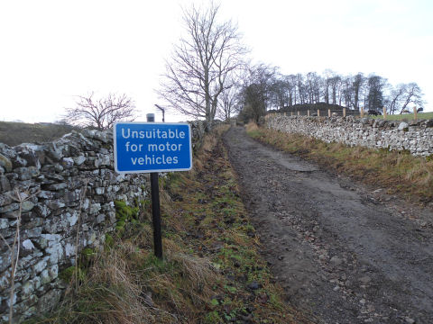
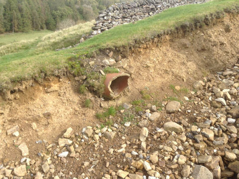
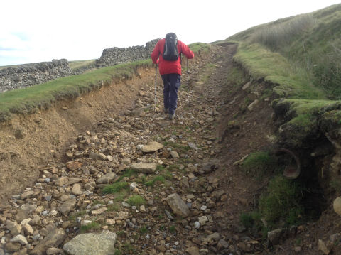
Illus 3 A wrecked green lane: Helwith-Skelton route Posted October 2017 A green lane, shown as an Other Route with Public Access (ORPA) on Ordnance Survey (OS) maps, runs from the hamlet of Helwith, in the valley of the Marske Beck, to near the hamlet of Skelton, in the same valley. he route crosses Skelton Moor, the steep northern and eastern edges (Cold Bank and Telfit Bank) of which force Marske Beck to flow east and then south between Helwith and Skelton. The route therefore gives fine views over the valley of the Marske Beck. Although close to the town of Richmond, this valley feels very remote and unspoilt because of its very small population. This area is close to, but not in, the Yorkshire Dales National Park. The route is maintainable by North Yorkshire County Council, but the level of public rights (foot, bridleway or vehicular) over it are not known. The northernmost 90 metres of the route are in the parish of New Forest; the remainder, 2.75 kilometres, from the ford and footbridge over Marske Beck just south of Helwith, is in the parish of Marske. Recreational use Three footpaths and four bridleways terminate on, or cross, this route, and most of it goes through open access land. It is therefore an important route for walkers, horse riders and mountain bikers. The whole of the route is included in a mountain bike route promoted by the County Council (the Marske Loop) and the southern end is used as part of circular horse-riding routes developed by the British Horse Society with the support of the Richmondshire and Bedale Bridleway Group and the County Council. At the northern end of the route, a tea room has recently been opened at Manor House Farm, Helwith. However, motor vehicle damage to this route has deterred users. One blog, describing a circular walk in the area of the Marske Beck, said in 2010 that this "valley is exquisite apart from the massive scar on the track leading out of the dale to the south-east which has been badly damaged by 4WD vehicles". A blog by a 4x4 user describing the drive from Skelton to Helwith in June 2011 said "One minute we were on a perfectly decent track and then round the corner we found ourselves at a frightening angle with no chance of turning back". He provides a photo from a 4x4 magazine showing deep uneven ruts on this section of the track; he also says that it took half an hour to descend this section because of the risks of turning over or grounding his 4x4. Temporary traffic regulation order (TRO) It is this section of the route, 770 metres between Munn End Gate and the ford over Marske Beck at Helwith, which is the subject of a temporary TRO, prohibiting motor vehicles (except for access to adjacent land for agriculture, land management or shooting). The temporary TRO was made in June 2016 by North Yorkshire County Council to protect the public from danger and to protect the road from further damage. It expires on 5 December 2017, unless the County Council applies for an extension to the Secretary of State for Transport. Condition of the route The following description is based on site visits by YDGLA in December 2016 and October 2017 and comparisons with photos from earlier years on www.geograph.org.uk. The temporary TRO was not signed at Munn End Gate until sometime between September and December 2016. The first section of the route is an enclosed track which climbs steeply (gradient of 14%) from the road north of Skelton, with a sign "Unsuitable for motor vehicles" at its start. Photos of this section taken in July 2015 shows a track with a firm surface which had some grass cover. By December 2016, the grass cover had disappeared in some places and the surface was eroding into gullies containing loose stone (see illustration 1).
Illus 1 After going through a gate, the route becomes unenclosed on one side, as it climbs Skelton Moor. A photo taken in July 2015 shows this section was a rutted track, which some motor vehicles have avoided by driving on the adjacent land (see illustration 2).
Illus 2 From the next gate, the route becomes unenclosed on both sides. A bridleway leaves it at this point (the continuation of the horse-riding route developed by the British Horse Society), both routes climbing up Skelton Moor. The bridleway has an unbroken grassy surface, but the ORPA here has a predominantly stony surface, sunk below the surrounding land, with evidence of tyre damage to the edges of the track (see illustration 3). Further on the route has three parallel ruts, indicating use by 4x4s and motorbikes; there are also tyre marks on the adjacent land.
Illus 3 There is no longer a gate at Munn End Gate, only the gate posts. The route descends from near this point to the ford crossing of Marske Beck. Although the gradient is less steep (10%) than the enclosed first section, the damage is worst on this section. The ruts are uneven in depth and are filled either with mud or scree-like broken stone, making them unsafe for any users, motorised or non-motorised (see illustration 4).
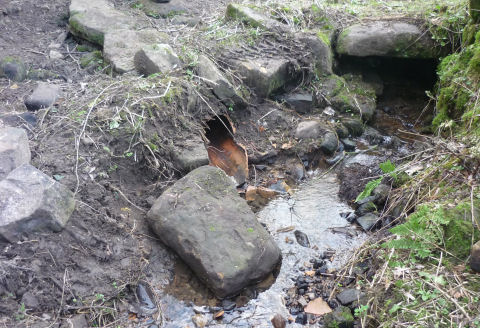
Illus 4 A drainage pipe, which was originally buried below the level of the track, has been exposed and destroyed (see illustration 5).
Illus 5 In some places, the ruts have merged, so that the line of the track is a deep stony gully with a shaley bedrock becoming exposed, a gully into which the adjacent grassy banks are collapsing (see illustration 6).
Illus 6 Users are taking to the adjacent grass to avoid the damage to this section of the track, but this alternative is not easy because the grass slopes downhill. Its use has already resulted in further scarring of the hillside (see illustration 7).
Illus 7 None of these sections is shown coloured as a road on large-scale (25 inch to 1 mile) OS maps from the end of the 19th century, unlike the short section north of the ford. This indicates that the sections of the route in Marske parish, south of the ford, have never been maintained for vehicular use. Future action by the County Council The County Council is planning to ask for an extension of the temporary TRO while it investigates and costs repairs to the TRO'd section and discusses joint funding. YDGLA thinks the County Council should also be investigating longer-term management of this route e.g. a permanent TRO (PTRO). This would be in line with the County Council's current management practice which states that if "major repairs are required then other options must be investigated to prevent damage re-occurring in the future which will require further repairs resulting in a cycle of unsustainable damage/repair" and that if "route repair to accommodate MPVs [mechanically propelled vehicles] will change the character of the route .. then the implementation of a PTRO should be considered along with any repairs made being in keeping with the local character and following PTRO implementation". Local residents and landowners have asked the County Council to close the route to recreational motor vehicles, saying that the temporary TRO is being ignored, that the motor vehicle use is dangerous to sheep, lambs and horse riders, and that farmers can no longer use the route for their own access (see http://www.darlingtonandstocktontimes.co.uk/news/15513646.New_way_sought_to_stop_motorists_destroying_green_lanes/) YDGLA considers that repairs are required to the badly damaged section of the route, to allow walkers, horse riders, mountain bikers to be able to use it, but that these repairs should not be such as to change the historic character of the route from one which was not considered as a road maintained for vehicles. We also consider that the temporary TRO should be extended to cover the whole route, so that recreational motor vehicle users approaching from the Skelton end are not tempted to ignore the restriction. The following purposes for a permanent TRO, provided for in legisation, are appropriate for the Helwith-Skelton route
The legislation says that authorities have a duty to use their powers to make permanent TROs, to secure the expeditious, convenient and safe movement of vehicular and other traffic (including pedestrians) having regard to the following matters:
The Helwith-Skelton route is not an expeditious or convenient route to the hamlet of Helwith; if it had been it would have been maintained as a road for vehicles at the end of the 19th century. Modern motor vehicle use has led to it becoming a slow (the 4x4 taking 30 minutes to drive about ½ mile in 2011) and unsafe route for all users.
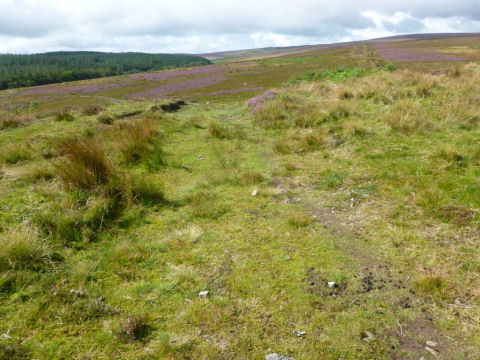
A report on the network of green lanes crossing Blubberhouses and adjacent moors Posted October 2017 The Ordnance Survey (OS) map, and North Yorkshire County Council's map of highways which it is responsible for maintaining, show a network of routes with unspecified public rights (unsealed unclassified roads, UURs) crossing Blubberhouses, Langbar, Middleton and Denton Moors and connecting to the A59, the Blubberhouses-Otley road and minor roads to the south-west, within the Nidderdale Area of Outstanding Natural Beauty (AONB). This network totals over 27 kilometres, most of which is across moorland, with the remainder through woodland or moorland fringe pasture. However some of the routes, in whole or in part, across moorland and in woodland, do not exist on the ground, despite being recorded as UURs (see illustration 1).
Illus 1 Some of those which do exist are unsurfaced, others are sections of surfaced shooting, forestry or farm access tracks, and a short section (less than 0.3 kilometres) is a tarmac drive to a house. The surfaced tracks, including bridges over watercourses, appear to be maintained by the landowners and occupiers, not by the County Council. History of the routes Part of one of the routes is shown on OS mapping as part of the course of a Roman road. Coming from the east, it joins the moor after leaving what is now the A59, east of Fewston Reservoir. However, neither this part of the route nor this part of the Roman road exist on the ground. Three of the routes pass old stone guide posts (stoops), with the distances to places such as Otley, Ilkley, Ripon, Skipton and Knaresborough carved on them. One of the routes is named High Badger Gate, indicating that it was an ancient route (Gate comes from the Viking word for a road or way) used by traders (badgers) either on foot or with pack horses. However part of the moorland area was subject to the Knaresborough Forest enclosure award in the second half of the eighteenth century, which would have reorganised (diverted, closed, created) the highways in the area. If the enclosure award had set out highways with public vehicular rights, YDGLA would expect these to have been enclosed with stone walls, to prevent animals from straying. However none of the routes are enclosed where they cross the moor, suggesting that none of these routes have public vehicular rights. Those with guide stoops and the one called High Badger Gate may be the relics of old packhorse routes, diverted or closed by the enclosure award. The earliest large scale (6 inch to 1 mile) Ordnance Survey map from 1853/4 supports this hypothesis in that it shows some of the routes as not physically existing throughout their length, suggesting that they were not or little used a century after the inclosure award. Recreational use The moorland area crossed by these routes is open access land, so walkers can use any of it. The route called High Badger Gate gives fine views south over the moorland towards Ilkley and Ilkley Moor. There is a bridleway which crosses the moorland from north to south, terminating on one of the routes. Sections of the routes which coincide with forest tracks have been waymarked by Yorkshire Water, the landowner, as part of a permissive bridleway. A comment on a mountain bike forum said in 2013 that the moorland routes "have improved massively since the TRO's were imposed" (http://singletrackworld.com/forum/topic/new-mountain-bike-trail-opens-harrogate) Natural beauty Nidderdale AONB's mapping of tranquillity (as measured by CPRE, the Campaign for the Protection of Rural England) shows that the A59 is, as might be expected, the least tranquil part of the AONB. However, the traffic noise from the section of the A59 adjacent to Blubberhouses Moor is largely contained by the gorge and valley which meets the Washburn valley at Blubberhouses, such that most of the moorland and other land crossed by this network of routes is mapped from the middle of the tranquillity spectrum to the most tranquil end. Considering how close the moor is to the great urban conurbations of Leeds and Bradford, it is remarkable that Blubberhouses can supply such a sense of wildness and tranquillity. Ecology The moors crossed by these routes, Blubberhouses, Langbar, Middleton and Denton Moors, form part of a large Site of Special Scientific Interest (SSSI), Special Area of Conservation (SAC) and Special Protection Area (SPA), i.e. their flora and fauna are protected by UK and European legislation. These designations and protection are because they contain wet upland heath, dry upland heath (one of the best areas in the UK) and blanket bog, which are important habitats for rare plants and for nationally important breeding populations of moorland birds, such as merlin. The blanket bog is also being managed (e.g. by blocking drainage grips) to improve its capacity to retain water and carbon dioxide, to improve water quality, help prevent flooding and mitigate climate change. In its management plan for this SSSI, Natural England notes that "repeated vehicle rutting of open land" and the construction of tracks are operations which are likely to damage the special interest of the site, i.e. the reason for its designation. The woodland through which three of the routes run, Timble Ings, is designated as a Site of Importance for Nature Conservation (SINC) because of its rich variety of habitats, flora and fauna. Previous Traffic Regulation Order (TRO) In 2005 North Yorkshire County Council made a zonal TRO covering all these routes and the moorland over which they pass, prohibiting all motor vehicles except for access. This TRO was recommended by a working group involving representatives from the County Council, the AONB, English Nature (now Natural England), North Yorkshire Police, Yorkshire Water, British Horse Society, Trail Riders Fellowship, Ramblers, Land Access and Recreation Association and YDGLA. The working group recommended the TRO "because of the significant damage which [vehicles] have caused to the moors over many years" and that it was "necessary to ensure these special areas are protected". This wording comes from the noticeboard which accompanies some of the TRO signs, and which also describes the importance of the area for wildlife. Some of the damage was to the unsealed and unsurfaced routes, but recreational motor vehicles also damaged areas of moorland away from the routes, possibly in attempts to find those routes which do not exist on the ground. The minutes of the working group show that the TRO was to last for five years, with monitoring of the moorland habitats to take place during this period. The noticeboard says that the "aim of the TRO is to give the affected parts of the moor a chance to recover, so that future generations can enjoy the moor". It goes on to say that the organisations involved in the working group "feel that the damage being caused is unacceptable and that these measures are necessary to ensure these special areas are protected". It is not clear what monitoring took place, as the working group does not seem to have met during the period of the TRO or afterwards. However, Natural England's most recent surveys of the moorland habitats in 2013 and 2014 do not report any damage from motor vehicles, indicating that the pre-TRO damage had healed. (A paper by English Nature, Natural England's predecessor, presented to the working group in 2004, said that Blubberhouses Moor was "the worst damaged moor in the country".) The comment on a mountain bike forum quoted above indicates that the routes which do exist on the ground had also improved "massively" as a result of the TRO. YDGLA walked all the route sections which exist on the ground (and looked at the termination points of those which don't) in August and September 2017 and found no evidence of damage by motor vehicles. We also found that areas of moorland which had been badly damaged by recreational motor vehicles before the zonal TRO, and which had partially recovered in 2009, four years into the zonal TRO (see illustration 2), were more or less completely healed by 2017 (see illustration 3). The TRO signs put up in 2005 were not removed when the TRO expired in 2010.
Illus 2
Illus 3 Current temporary TRO In May 2016 North Yorkshire County Council made a temporary TRO covering this network of routes, prohibiting all motor vehicles except for access to premises. The reason for the order was to prevent damage to the roads. This TRO expires on 11 November 2017, unless the County Council applies to the Secretary of State to extend it. Possible actions by the County Council YDGLA considers that the County Council should apply to the Secretary of State for Transport for an extension to the temporary TRO. The County Council should also consider the options for managing this network of routes while the temporary TRO is in place, in line with its practice on managing UURs. These options are: do nothing; appeal for voluntary restraint; impose a permanent traffic regulation order; repair. We think that doing nothing (other than extending the temporary TRO) is not the option of choice, because temporary TROs can be extended only three times (i.e. for a maximum of 4 ½ years) and because some of the damage which the zonal TRO cured was to areas of moorland where there is no road on the ground (or even on the map). Nor is voluntary restraint, because the evidence from the vehicle logger on another North Yorkshire UUR, Deadman's Hill, is that not all recreational motor vehicle users obey voluntary restraint. Nor is repair; the sections of UUR which coincide with shooting, forest or farm access tracks are kept in repair by the owners and occupiers, and the unmaintained sections have either recovered during the TROs or do not exist on the ground. ). Furthermore, Natural England's permission would be required for the construction of new tracks over the moorland, because of the risk of damage to the habitats. The far and away preferred option should be a public consultation on making a new permanent TRO (and to allow time for the consultation and decision-making process. We therefore suggest that the County Council consider the following reasons for a permanent TRO, in addition to the reason for the temporary TRO, of preventing damage to the roads:
It may be argued that a permanent TRO is not needed because damage to the SSSI away from the existing surfaced shooting tracks can be prevented by notices warning users that they risk prosecution for intentional or reckless damage to the features for which the SSSI is designated. However this would not protect the unsurfaced routes (i.e. those which were protected by the 2005 TRO), and enforcement would be virtually impossible (unless a vehicle got stuck in blanket bog), especially as some of the routes are not defined on the ground. The County Council could not construct highways where they are not defined on the ground, or surface unsurfaced routes, because this would be likely to damage the special features of the SSSI. (This is one of the reasons why the options for diverting the A59 through this area have been rejected by the County Council.) Some of the surfaced shooting tracks are dead-ends and the others do not coincide with the publicly maintainable highways throughout their length, so that it is not possible to put together a through route for the public with motor vehicles to cross the area without the use of unsurfaced routes. YDGLA therefore thinks that the only way to continue the protection of the SSSI is by making a new zonal TRO, which would also benefit non-motorised users of the area by preserving the character of the routes and the natural beauty of the area. The legislation says that authorities have a duty to use their powers to make permanent TROs, to secure the expeditious, convenient and safe movement of vehicular and other traffic (including pedestrians) having regard to the following matters:
However, none of this network of unsealed routes are convenient or expeditious for motor vehicle traffic by the public. As noted above, it is not possible to design a through route using this network without including unsurfaced routes, which would not be convenient or expeditious.
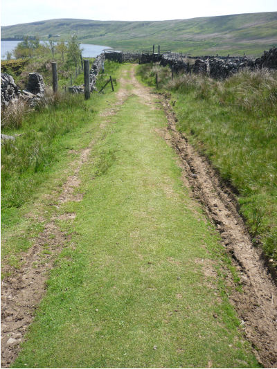
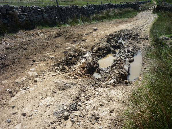
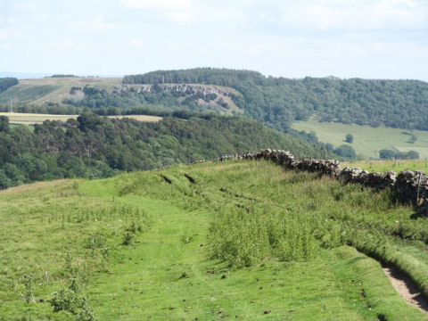
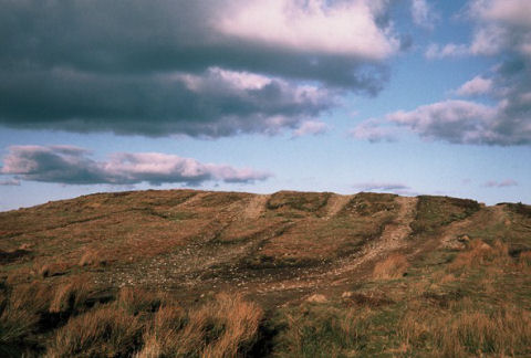
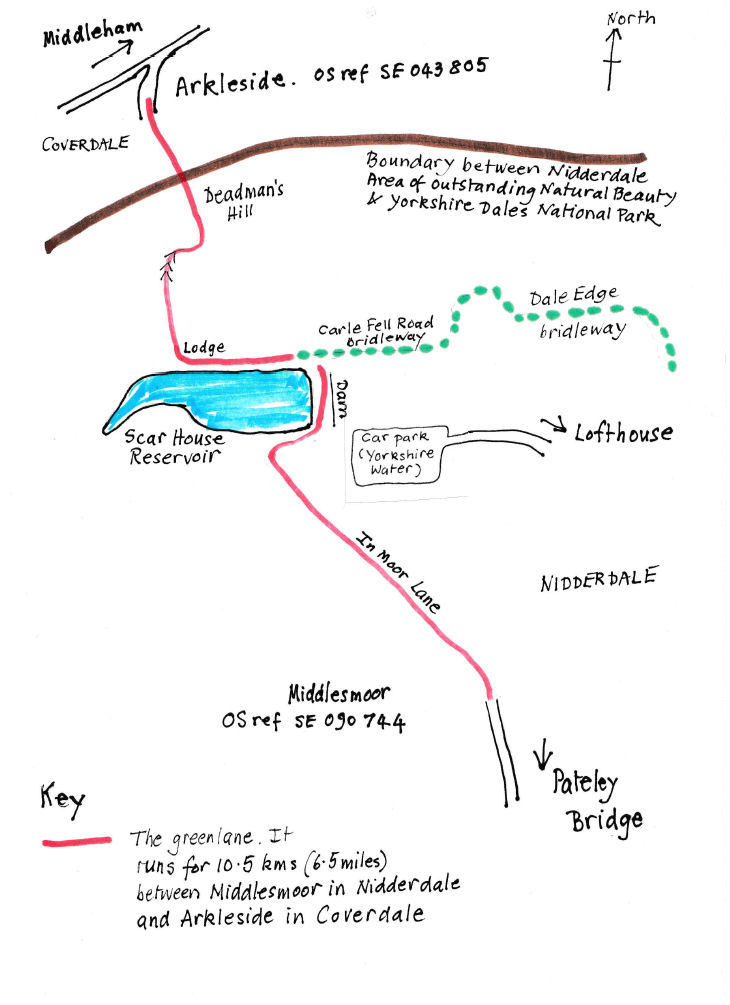
A report on the history and present condition of Deadman's Hill Posted 3 October 2017 Deadman's Hill is part of an ancient cart track which ran north from Middlesmoor in Nidderdale, via the hamlet of Lodge, to climb over the watershed near the head of Nidderdale to Arkleside in Coverdale. When Bradford Corporation built Scar House Reservoir across the cart track in the 1930s, the track was diverted to run across the dam and then along an old bridleway to Lodge (see illustration 1).
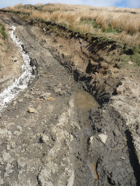
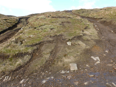
Illus 1 - Sketch map of route of the green lane that runs from Middlesmoor to Arkleside. At 10 ½ kilometres, this route from Middlesmoor to Arkleside is one of the longest green lanes in the Dales, and runs for most of this length through remote and beautiful country. However, recreational motor vehicle use has spoilt the beauty of parts of this route.In Moor Lane, the section of the cart track between Middlesmoor and the northern end of Scar House dam, is a byway open to all traffic (BOAT), i.e. recreational motor vehicle drivers have the right to use it. Its continuation, Deadman's Hill, is an unsealed unclassified road, i.e. it is maintainable by North Yorkshire County Council, but most of it is not on the definitive map of public rights of way, so the level (on foot, bridleway or vehicular) of public rights has not been defined. A short length between the northern end of the dam and the junction with Carle Fell bridleway is recorded as a bridleway on the definitive map, so motor vehicle use of this section is illegal. However this prohibition is not signed or enforced as the area is so remote. Under current law, the remainder of Deadman's Hill would become a BOAT, if it were added to the definitive map, because its public rights derive from historic horse-drawn cart use. The short section which is currently bridleway would become restricted byway i.e. open to horse-drawn vehicles but not motor vehicles, in line with the historic use of the whole route. In Moor Lane and Deadman's Hill do not serve any habitations; the buildings (on the site of a monastic grange) at Lodge have been ruins for many years. Yorkshire Water's private road provides access for its own properties and some farms between the two reservoirs, Scar House and Angram, at the head of Nidderdale, and Lofthouse, south-east of Middlesmoor. Most non-motorised recreational users access Deadman's Hill by driving along the private tarmac road owned and maintained by Yorkshire Water, to a car park provided by Yorkshire Water, near the dam. They can then walk to the dam and onwards via Deadman's Hill to use the 3 footpaths and 2 bridleways which join it, to walk the access land it passes through, or to cycle around Scar House reservoir (Yorkshire Water allows cyclists on the footpath which makes a circular route from Deadman's Hill at Lodge around the reservoir). Some motorised recreational users use the private road, passing a no entry sign to reach the dam, but others use In Moor Lane. Yorkshire Water has had to place boulders where the private road is unfenced to stop off-road vehicles using the hummocks, where the village which housed the workers who constructed Scar House and Angram reservoirs was, as a playground. YDGLA saw hoof-prints on the Coverdale section in July 2007, but it was clear that the horses had been unable to descend the badly-damaged AONB section without deviating from the track to find a safer way over the moorland. We suspect that few or no horse riders have used the route since. Sensitivity assessment Yorkshire Dales National Park Authority (YDNPA) carried out an assessment of its green lanes with proven or possible public rights for recreational motor vehicles in 2006, including the Coverdale section of Deadman's Hill. (The Nidderdale section and In Moor Lane are in the Nidderdale Area of Outstanding Natural Beauty, AONB). This assessment showed that the Yorkshire Dales National Park section of Deadman's Hill was likely to be highly sensitive to motor vehicle use, primarily because of its tranquillity, but also for its ecology, heritage and surface. Because of this assessment, YDNPA has been monitoring the surface condition and motor vehicle use of its section of Deadman's Hill since 2007, as it has with its other highly sensitive green lanes. However, unlike the other highly sensitive lanes, YDNPA sees it as the County Council's responsibility to manage the route, and to consider a traffic regulation order (TRO) restricting motor vehicle use, as YDNPA does not have the power to make a TRO on the Nidderdale section. The elements of YDNPA's sensitivity assessment are examined below, as they apply to the whole route. Tranquillity YDNPA found that Deadman's Hill was in a very tranquil part of its area; Nidderdale AONB's analysis of tranquillity found the same for its section. The only noise which disturbs the area of Deadman's Hill is grouse-shooting on the National Park side, and the use of 4x4s and motorbikes on Deadman's Hill. Ecology Deadman's Hill goes through upland grassland and heather moorland, with acidic peaty soils, a good habitat for birds such as oyster catchers. Recreational motor vehicle use of the steepest section of the track, and their creation of an alternative track at this point, has broken through the surface, leading to erosion of the underlying peat. (See illus 2 & 4.)
Illus 2 - April 2015: the track had been eroded by up to 2 metres below the level of the surrounding moorland.
Illus 4 - March 2013: motor vehicle users have damaged the adjacent moorland, cutting the corner of the track. This area adjacent to the route has become a vehicle users' playground. This will have affected the ability of the peat to act as a carbon sink, and so will have increased the release of carbon dioxide, a greenhouse gas, into the atmosphere. Heritage As described above, most of Deadman's Hill follows ancient tracks. However, motor vehicle use has completely destroyed any trace of the historic track on the steep section uphill from Lodge. (See illus 3)
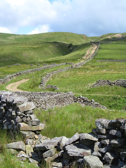
Illus 3 - July 2015: The foreground looks pretty good, but higher up the slope, where it steepens, the track has braided into parallel tracks as vehicle users have carved out alternative routes. (Photo Copyright Gordon Hatton, licensed for reuse under creativecommons.org/licenses/by-sa/2.0) Surface condition The first part of Deadman's Hill, travelling from Nidderdale to Coverdale, takes a relatively level route from the junction with Carle Fell bridleway to Lodge. Despite the drainage installed at the sides and under the route in 2000 (see below) and subsequent maintenance, surface damage means that there are potholes and puddles on this section. From Lodge, the track rises steeply towards the watershed; much of this section has been repaired and drainage added in 2013 and 2017 by the County Council. (See illus 5)
Illus 5 - : July 2017: the County Council has restored the moorland, added cross and side drains to the track and surfaced it. This is the section pictured, 2 years earlier, in illustration 1. Whether this repair will survive the re-introduction of 4x4s and motorbikes remains to be seen. The next, flatter, section crossing the watershed used to be badly damaged; a photo shows a 4x4 stuck in peat bog here. But repair work by the authorities and the landowner on the Coverdale side, including the construction of a subsoil track with a permeable geotextile membrane, has resulted in improvements to this and the succeeding descent into Coverdale. Repairs by the County Council The County Council undertook extensive repairs to Deadman's Hill in the late 1990s, as a result of a section 56 (out of repair) notice issued by a member of the public. Since then the AONB section has been repaired 3 times at decreasing intervals, first by County Council and recreational motor vehicle users in collaboration with Yorkshire Water in 2000, and then by the County Council in 2013 and in 2017 The 2017 repairs cost £26,000 and involved removing the ruts, regrading the surface, improving the drainage and regenerating the adjacent moorland which had been damaged by being used as an alternative route. The County Council's current note on the management of unsealed unclassified roads says that the "routes which display the worst damage are often those with the steepest gradients where vehicles can wheel spin in poorer weather conditions, loosening and removing surface material ... [and] ... those routes running across peat fields...". It comments that once "the surface stone (if present in the first place) has been damaged or effectively removed through use, the level of the route becomes lower than the adjacent land and then acts as a drainage ditch for this surrounding land. From this point on, damage can occur rapidly, making routes especially dangerous ... where routes have steep cross-falls." Photos taken before and after the most recent repairs show that part of the Deadman's Hill track runs in such a ditch and that the County Council has had to create drainage grips and ditches to try to divert the water. A photo taken in July 2015 shows how the steep section of the track has been widened, and alternative tracks formed, creating scars on the hillside, as recreational motor vehicle users drove off the route to avoid the ruts. (see illustration 4) This was during a period when the umbrella organisation for recreational motor vehicle users, the Land Access and Recreation Association (LARA), had placed signs at either end of the route asking 4x4 and motorbike drivers to travel from north to south only, "to avoid damaging lane" because it thought that driving the steep section of the route downhill would not damage it. It appears that this request for restraint was widely ignored, or that LARA's assumption about the direction of driving was incorrect. Motor vehicle numbers Yorkshire Dales National Park Authority has had a vehicle logger to record the numbers and types of motor vehicles using its section of the route since 2007. This logger shows that, on average between 48 and 58 motorbikes use this section of the route each month, but this number reduced significantly when the County Council had a temporary TRO on the whole route, e.g. to 9 per month in 2012. The numbers of 4x4s recorded by the logger are higher than the number of motorbikes, but a significant proportion of these 4x4s are thought not to use the AONB section of the route, being vehicles used for grouse management and shooting, which take place only on the Coverdale side of the watershed. Management options The County Council's current note on management of unsealed unclassified roads says that if "major repairs are undertaken, the route must be formally monitored regularly thereafter to assess condition" and that in "the event of any further damage introduction of a permanent TRO should be considered if appropriate to save the route from requiring further and repeated major repair". YDGLA thinks that the repeated repair of the AONB section of Deadman's Hill by the County Council shows that its use by recreational motor vehicles is not sustainable and that a permanent TRO is needed. A permanent TRO prohibiting recreational motor vehicle use of Deadman's Hill could be made for the following reasons, all of which are set out in the regulations governing TROs:
The legislation says that authorities have a duty to use their powers to make permanent TROs, to secure the expeditious, convenient and safe movement of vehicular and other traffic (including pedestrians) having regard to the following matters:
There has been no need for expeditious and convenient vehicular access to Lodge from Middlesmoor and Coverdale since the hamlet was deserted soon after the reservoir was completed in the 1930s. The landowners and occupiers do not use Deadman's Hill as a through route. Motorists who wish to drive from Middlesmoor in Nidderdale to Arkleside in Coverdale can use a route on tarmac roads maintained by the County Council, a route which, although longer than In Moor Lane and Deadman's Hill, is accessible to all motor vehicles, and legal throughout (unlike Deadman's Hill where motor vehicle use of the bridleway section is illegal). Deadman's Hill and In Moor Lane are only accessible to off-road capable motor vehicles. YDGLA therefore considers that Deadman's Hill is not necessary for the expeditious and convenient movement of vehicular traffic, and that a permanent TRO would improve the amenity of non-vehicular recreational users of this superb track.
A new green lane group is founded to tackle problems on the North York Moors Posted 26 November 2016 We are pleased to announce the formation of the North York Moors Green Lanes Alliance. YDGLA's own territory is restricted to the Dales National Park and the Nidderdale Area of Outstanding Natural Beauty, but we have long been aware that there are severe problems on the North York Moors. A local group there, in which horse-riders are strongly represented, has gone into action to persuade NYCC and the North York Moors National Park Authority that many green lanes in their charge are damaged to such an extent that they are unusable by walkers, cyclists and equestrians. The new group, NYMGLA, may be contacted at nymgla@btinternet.com
The Dales National Park expands its borders Posted 26 November 2016 The expansion of the national park westward, right up to the M6, increases the number of green lanes that the park authority will have to look after. Notably, Lady Anne's Highway, which formerly exited the park at Hell Gill Bridge, above Mallerstang, is now within the park for its whole length. A TRO is in place on the original section. Maybe a TRO needs to be put in place to protect the new, northern section.
The 'Stakeholder Working Group' on vehicles in the countryside, set up by the government. Posted 25 November 2016 In the dying days of the Coalition, a government minister acknowledged that the damage and general nuisance inflicted by recreational vehicles on green lanes is a problem that needs a solution. He undertook to set up a 'stakeholder working group', composed of representatives of all groups with an interest in green lanes. The purpose of the group would be to make recommendations to government about changes in the law thought to be necessary. However, this undertaking has been watered down so much that it is scarcely an undertaking at all. All that was finally offered by the incoming, current government was a one-off, one-day forum at which it was hoped that a consensus would emerge on the best way to manage green lanes. This hope, we think, was disingenuous. There was not the slightest chance that a one-day meeting would produce a consensus: the views of the vehicle users, and the views of those who wish to see non-essential vehicles prohibited from green lanes are far too far apart for a swift accommodation to be made. The forum met on November 17, under the auspices of DEFRA and English Nature. In her introductory remarks, the chairwoman made it clear that Brexit will command so much of Parliament's time for the foreseeable future that it will be extremely difficult for non-Brexit legislation to be considered. Furthermore, she said, DEFRA will not consider revising the advice it gives to Highway Authorities and National Park Authorities on the management of green lanes. Lastly, she told the forum that official support for its deliberations would cease. From now on, anything the Forum chose to do, it would have to do under its own steam. Altogether, not a very encouraging introduction. But the members of the Forum ploughed on, and set up sub-groups to consider various aspects of the problem - the use of traffic regulation orders, or the value, if any, of schemes for voluntary restraint by vehicle users, for example. Whether the Forum will come up with anything useful, and whether anybody will take any notice, is unclear, but we will remain engaged with it. Meanwhile, we will continue to make our way along the avenues that remain open to us. This means trying to persuade North Yorkshire County Council, and, to a lesser extent, the Dales National Park Authority, to impose traffic regulation orders on green lanes where the damage and nuisance inflicted by 4x4s and motorbikes is at its worst. Deadman's Hill, which runs through YDGLA like a watermark, is the obvious case in point. It may be the case, although we cannot be confident, that NYCC if finally taking the problem seriously, and getting a grip on it.
Good news concerning Deadman's Hill and Blubberhouses Moor Posted 13 April 2016 The state of the track going over Deadman's Hill from Scar House, in Nidderdale, to Arkleside, in Coverdale, has, for years, been steadily deteriorating. The summit section is now an impassable morass (see photo).
At last, North Yorkshire County Council, having seen that its repairs, costing £20,000, are completely incapable of withstanding the impact of recreational 4x4s and motorbikes, has imposed an 18-month traffic regulation order, starting on 4 April 2016. Unlike previous TROs, which were imposed in order to make repairs, the purpose of the new TRO is 'to protect the public from danger and to protect the road from serious damage'. This means that vehicle users cannot demand that repairs are made and the route re-opened. There is now a chance that the temporary TRO will be followed, after public consultation, with a permanent TRO. If this comes about, this superb track in remote upper Nidderdale will return to the tranquil state it was in before 4x4 and motorbike users devastated it. It will take a long time for the fabric of the track to recover, but a valuable start has been made. Further good news is the forthcoming renewal of the permanent TRO on the network of tracks that criss-cross Blubberhouses Moor. (The moor is to the south of the A59 Harrogate-Skipton Road, between Blubberhouses church and Langbar,) Considering how close this moor is to the Leeds/Bradford connurbation it is capable of achieving a remarkable sense of peace and tranquillity. It also has extensive Sites of Special Scientific Interest. However, large tracts of the moor, along with the peace and quiet, were wrecked by 4x4s and motorbikes. The imposition of the TRO has led to a spontaneous, natural regeneration of some of the damaged sections, although English Nature say that some sections are irreversibly ruined. Recreational vehicle user groups supported the imposition of the first TRO. We congratulate them, and hope that their support will continue as the TRO is renewed.
New MP accepts honorary membership of YDGLA Posted 25 September 2015 When YDGLA was founded, back in 2002, we invited all three MPs whose constituencies include parts of the Yorkshire Dales National Park and the Nidderdale Area of Outstanding Natural Beauty, to become honorary members of YDGLA. All accepted. Since then, two of the three have retired from Parliament. We are very pleased to say that their successors have followed on, accepting honorary membership. The latest is Rishi Sunak MP, who succeeded William Hague in the Richmond constituency. Tim Farron MP and Julian Smith MP complete the trio. We have always known that if YDGLA failed to express the views of people in the Dales, we would be sidelined. The honorary membership of all three MPs fortifies our view that we are speaking for the great majority of residents of, and visitors to the Dales. Green lanes are wonderful, distinctive features of the landscape, and people want them to be freed from the blight of 4x4s and motorbikes.
Deadman’s Hill and the effect of ‘voluntary restraint’ by vehicle users Posted 19 April 2015 The story so far. Deadman’s Hill, the name given to the track that runs from Arkleside in Coverdale to Middlesmoor in Nidderdale has, for many years, been pretty much ruined by 4x4s and motorbikes. In August 2010 North Yorkshire County Council, recognising that the stretch from Lodge up to the watershed between and Coverdale was more or less impassable, imposed a temporary TRO (see glossary) for 18 months. The idea was to make repairs and then re-open it. No repairs were made during this period of closure. The TRO was extended for a further 18 months, during which time repairs were made to the actual right of way, and attempts were made to prevent vehicle users from illegally going off-piste and spreading their impact even wider. Precise figures are hard to come by, but the cost of the repairs was in the region of £20,000. The track was re-opened in August 2013.
Now read on. As we predicted, the renewed onslaught of vehicles steadily demolished the repairs. Even members of the motorcyclists’ association, the TRF (see glossary) recognised that the track was deteriorating. Under the auspices of the vehicle users’ umbrella group, LARA, a code of ‘voluntary restraint’ was devised and promulgated. A sequence of un-ignorable signs along the track entreats vehicle users to drive and ride only in a north-to-south direction, thus ensuring that the morass near the summit will be tackled going downhill, thereby, it is hoped, reducing the vehicles’ impact. The impact of vehicles lower down the hill, no matter in which direction they are travelling, has led to deep rutting. (See photo)
This section of the track was repaired and levelled 18 months ago On Saturday 18 April, YDGLA members made a visit. In places, the state of the track is worse than before the repairs were attempted. Near the summit, the route is impassable for cyclists and equestrians, and negotiable only with difficulty by pedestrians. (See photo)
This section of the track, too, was repaired
18 months ago. The photo shows the
The familiar noise of motorbikes, echoing across the bare fells, heralded the arrival of a convoy of eleven motorbikes, defying LARA’s north-south entreaties by riding, uphill, from south to north. When they reached the impassable morass, they took one look at it, and veered off-piste, riding along the bank that borders it, and re-joining the right of way at the summit. So much for voluntary restraint. (See photo)
The right of way runs at the bottom of the picture
North Yorkshire County Council has thrown £20,000 down the drain. As we, along with local residents, landowners, and non-motorised users, have long argued, the only effective solution is a permanent TRO, prohibiting recreational vehicles. The green lane will then, eventually, naturally recuperate, and recover its former tranquil beauty.
Good news and bad news from the Supreme Court Posted 24 March 2015 On 18 March 2015 the Supreme Court handed down judgment on two important issues. First the bad news. The court was asked to give a final ruling on the ‘Dorset Case’. (See our posting below, dated 20 July 2013.) Maps submitted in support of applications for Byways Open to all Traffic (BOATs: see glossary) have to be at the scale of 1:25,000. The Supreme Court’s job was to rule whether a computer-enlargement of a map drawn to a scale of 1:50,000 may count as a map drawn to a scale of 1:25,000. The Court, by a majority of 3 judges to 2, ruled that it could. The effect of this ruling is that a small number of BOAT applications in Dorset will have to be processed to a conclusion, thereby giving 4x4 and motorbike users more green lanes for their pastime. Fortunately for us in the Dales, there are no pending BOAT applications that will be activated by this ruling. Now for the good news. The Trail Riders’ Fellowship (TRF: the motor cyclists’ organisation) had hoped to use their challenge to the map-scale rule as a bridgehead to the overturning of the ‘Winchester Judgement’. This judgment, affecting around 880 BOAT applications, means that the evidence upon which the applications rely has to accompany the applications when they are submitted. The TRF has always argued that a simple list of the supporting evidence, not the evidence itself, satisfies the regulations. They were, naturally enough, reluctant to see nearly a thousand BOAT applications go down the tubes. The Winchester Judgment was not formally part of the TRF’s challenge in the Supreme Court to the map-scale question, but 3 of the judges delivered their view that Winchester was sound.
Win some, lose some.. The BOAT applications whose maps now pass muster are a distinct loss to those who want quiet, undamaged, vehicle-free green lanes in Dorset.But the hundreds of applications that were ruled as non-compliant by Winchester, and whose non-compliance has been confirmed by the highest court in the land, are a big win.
Promising developments in Parliament Posted 9 February 2015 The Green Lanes Protection Group, of which YDGLA is a member, encouraged members of the House of Lords who are concerned about the damage and nuisance caused by recreational vehicles on green lanes to submit an amendment to the Deregulation Bill, which is currently making its way through Parliament. (See the posting below, 17 May 2014) As we expected, the amendment, which sought to have all unsealed green lanes classified, en bloc, as Restricted Byways, was ruled out by the government. We knew that we were being wildly ambitious, but nothing ventured, nothing gained. But despite the demise of our amendment, we have indeed gained, and gained substantially: the amendment had the salutary effect of encouraging the government to commit itself to the setting-up, as soon as the Deregulation Bill becomes law, of a ‘Stakeholder Working Group’, charged with making recommendations, within 18 months, on all questions relating to motor vehicles on green lanes. The government’s commitment came in a Lords debate on 3 February, and thus gave us the best news we’ve had since the passing of NERC. The membership and precise terms of reference of the group are yet to emerge, but it is hard to imagine that a group on which representatives of all bodies that have an interest in green lanes - farmers, land-owners, walkers, cyclists, parish councillors, naturalists, national parks - will bring much comfort to the motorbike and 4x4 brigades. Obviously, recreational vehicle users need to be represented by LARA, or the TRF presumably - on the Stakeholder Group, but they will neither be able to call the shots, nor to exercise a veto over recommendations that don’t suit them. The group will not be obliged to deliver a consensus: majority and minority reports will be acceptable.
One large group of green lanes 3,000 miles of them whose fate, at present, is dire, will benefit from the deliberations of the Stakeholder Group. These are ‘unclassified county roads’ (UCRs) (See glossary). If nothing is done soon, the arrival in 2026 of the cut-off date for the entry of further rights of way on to the Definitive Map, will send UCRs into a limbo whose sole beneficiaries will be recreational motorists. But when the new Stakeholder Working Group gets down to work, we hope that it will come up with the recommendation that UCRs should be classified as restricted byways, and entered on the Definitive Map as such.
When the Stakeholder Group delivers its recommendations, a public consultation will be mounted. We will then see whether the public wants motorbikes and 4x4s to have access to green lanes, or if it wants to preserve green lanes for non-motorised recreational use, along with motorised use by farmers and other essential users.
With the aid of powerful binoculars, the promised land of traffic-free green lanes may just about be in sight.
We are not alone Posted 13 January 2015
Deregulation Bill Posted 17 May 2014 The government has recognised that something has to be done about the status of unsealed unclassified county roads (UUCRs), but rather than accept the amendment that was put forward in the Commons, seeking to classify UUCRs as Restricted Byways and thereby to close them permanently to recreational motors it has proposed the setting up of a ‘stakeholder working group’ to examine the problem. Such a group would be composed of all those who have an interest in green lanes, including representatives of both pro- and anti-vehicle groups. The group would be charged with the job of coming up with a consensus on the fundamental question of whether the 3,000 odd miles of UUCRs should be closed to, or be open to recreational motorists. This is rather like charging the Pope and Richard Dawkins to produce a consensus on the question of whether or not there is a god. The government, in other words, is ducking the issue and fending it off, for years, by the setting up of a group that, by the very nature of the issue, will end in stalemate.
However, the amendment designed to classify all UUCRs as Restricted Byways is by no means dead. It will make its reappearance when the Lords debates the Deregulation Bill, and there’s a fair chance that their Lordships will support it. Whether the Government will then respond to the way the wind is blowing and incorporate the amendment into the final version of the bill remains to be seen.
The ‘Deregulation’ Bill: an opportunity for Parliament to free virtually all green lanes from recreational motor vehicles, permanently. Posted 30 December 2013 When Parliament issued a call for evidence on aspects of the forthcoming ‘Deregulation’ bill, members of the public, and organisations (including YDGLA) responded by making the case for the re-classification of green lanes. Green lanes, we argued, should be re-classified, by law, as restricted byways. This would mean that they will remain open to pedestrians, pedal cyclists, horse-riders, carriage drivers, and essential motor vehicle users, but would be freed from the blight of those who ride motorbikes or drive 4x4s, for pleasure, along green lanes. In essence, our recommendation is this:
The case was persuasively argued by a colleague from the Peak District Green Lanes Alliance before the committee set up by Parliament to scrutinize the new bill. The committee issued its report on 19 December. The report’s conclusion is that our proposal is somewhat beyond the remit of the bill. We half-expected this, for we knew that we were reaching for the stars: but if you don’t ask, you don’t get. However, the report by no means rubbishes our proposal. On the contrary, the committee say that the volume of responses to the call for evidence makes plain the public’s concern about the damage and nuisance inflicted by recreational motors on green lanes. The report recommends Parliament to turn its attention to the problem, if not in the Deregulation Bill, then in further legislation.
We still believe that our proposal can be incorporated into the forthcoming bill, and hope that the necessary clauses will there when the Deregulation Bill is published. If such clauses are not in the bill when it is published, we will continue to argue that unsealed BOATs and UCRs should be reclassified as restricted byways, and will press for amendments as the bill makes its way through Parliament.
We have caught a glimpse of the possibility of an end to recreational green lane motoring. Whether the eventual Deregulation Act will carry us into the promised land remains to be seen. But there are plenty of signs of public and parliamentary support for our proposals, and we must continue to press for measures that will finally put an end to the destructive and anti-social practice of taking 4x4s and motorbikes, for pleasure, miles away from the tarmac, into peaceful and tranquil countryside.
The Parliamentary committee’s report can be found at http://www.publications.parliament.uk/pa/jt201314/jtselect/jtdraftdereg/101/101.pdf. Our proposals are considered in paragraphs 147-154.
Developments in the ‘Dorset Case’ (see the posting for 3 October 2012, below) Posted 20 July 2013 Our 3 October posting was prematurely optimistic. We reported that the High Court had ruled that maps of claimed routes have to be drawn at the prescribed scale (1:25,000). Maps that are computer-enlargements of maps drawn at a smaller scale must be rejected by authorities determining applications. However, vehicle users successfully appealed against this ruling. A new judgment has been handed down. It turns on what is meant by the word ‘drawn’, in such phrases as ‘a map drawn to the prescribed scale.’ If this new judgment stands, it means that if you press the key on your computer that blows up an image of a 1:50,000 map to 1:25,000, you (or maybe the computer) are ‘drawing’ the map to the prescribed scale. Whether this latest legal judgment will stand is unclear. There is a yet higher court to which an appeal may be made, but it is not known whether such an appeal will be lodged. As we said in our 3 October posting, the fate of numbers of green lanes (although none, we are relieved to report, in the Yorkshire Dales), will be determined by the ultimate legal ruling on whether a computer-enlargement of a small-scale map is equivalent to a map originally produced at a larger scale.
Ten traffic regulation orders on green lanes in the Dales National Park renewed Posted 20 July 2013 Five years ago, the Yorkshire Dales National Park Authority succeeded in imposing traffic regulation orders (TROs) on ten of the most sensitive and beautiful green lanes in the Park*. Although the orders were permanent, the Authority has a policy of reviewing them after five years. The first five years are up. The condition of the surface of all ten lanes is much improved transformed in some cases but it is important to recognize that the orders were not made on the grounds of surface-damage. The orders were made in order to protect the special qualities of the national park. This means that anyone arguing that the orders, or some of them, should be discontinued or modified would have to show that the park’s special qualities no longer need the protection that has been provided by the TROs. Not surprisingly, no such arguments were produced. The Authority, at its June meeting, renewed all ten orders. The ten green lanes are safe for a further 5 years.
* Barth Bridge, Cam High Road, Carlton to Middleham High Moor, Foxup Road, Gorbeck Road, The Highway, Horsehead Pass, Ling Gill, Long Lane (Clapham to Selside), Mastiles Lane.
Traffic Regulation Order on Deadman’s Hill about to be discontinued Posted 20 July 2013
Roundup of recent legal cases Posted 20 Jan 2013 A number of developments in the legal world, away from the Yorkshire Dales, will have implications for our own green lanes. The List of Streets. The Appeal Court has issued a complicated judgement about the List of Streets. The Natural Environment and Rural Communities Act (NERC), which has done so much to limit the expansion of the network of green lanes open to recreational motors, did not deal with those tracks known as ‘unsealed, unclassified county roads’ - UUCRS. NERC says that any route that (a) has proven rights for motor vehicles, (b) is not on the Definitive Map, and (c) is entered on the Highway Authority’s List of Streets Maintainable at Public Expense, continues to bear motor vehicular rights. This gap in NERC’s provisions leaves a large network of green lanes entirely unprotected from the damage and nuisance caused by recreational 4x4s and motorbikes. All is not lost, though. The question ‘What constitutes a valid List of Streets?’ arises. Highway authorities have customarily compiled a variety of often overlapping, and sometimes contradictory and incomplete Lists. The NERC Act brought these hitherto not very important informal methods of public record-keeping into sharp focus. If NERC preserves motor vehicle rights on routes that are on the List of Streets, what happens - and this is the key point - if the Authority did not have a valid List of Streets on which those routes were entered? A case in Wiltshire was tested in the Appeal Court. The Court’s ruling is lengthy and complicated, and its full impact is yet to be felt, but it will be tested, up and down the country, whenever there is the chance that an authority’s List of Streets can be shown to have been defective, and therefore cannot be relied on as a mechanism for preserving motor vehicular rights on UUCRS. (http://www.bailii.org/ew/cases/EWCA/Civ/2012/334.html)
Experimental Traffic Regulation Order in the Peak District. The motorcyclists’ lobby group, the Trail Riders’ Fellowship (TRF) has successfully challenged, in the High Court, an experimental traffic regulation order (ETRO) imposed on a green lane (Chapel Gate) by the Peak District National Park Authority (PDNPA). ( http://cornerstonebarristers.com/case/trail-riders-fellowship-v-peak-district-national-park-authority-2012-ewhc-3359-admin/ ) The judge found that the Authority had not adequately set out the precise nature and purposes of the experiment that was to be conducted. This was an own-goal by the Authority. Some years ago, North Yorkshire County Council, in collaboration with the Yorkshire Dales National Park Authority, successfully imposed a number of experimental traffic regulation orders. Its procedures could easily have been replicated by its colleagues in the Peaks. The lesson here is that the motoring lobby has sharpened up its act: it will scrutinise every dot and comma of every regulation that seeks to limit its activities, and will head for the High Court whenever it sees a chance. The courts have found no insuperable legal obstacles, in principle, to the imposition of various sorts of traffic regulation orders, but they have found defects in a few of the orders that the TRF has challenged. The result is that Authorities have to pay huge legal costs, and then go away and re-make the orders, taking account of the judge’s strictures. The TRF thereby wins brief skirmishes in a war that they are steadily losing. If Authorities made their orders properly in the first place, time and money would be saved.
PDNPA carried out comprehensive monitoring on Chapel Gate before and during the ETRO. The results of the monitoring show that:
Sounds familiar?
http://www.peakdistrict.gov.uk/__data/assets/pdf_file/0003/295833/MR1210-ChapelGate.pdf
Challenge to the fundamentals of NERC. Lastly, as the motoring lobby desperately tries to pick holes in the fabric of the NERC Act, more and more obscure tactics are being tried. In the Dales, and recently in Northumberland, it was argued by the TRF that the meaning of rights of way designations must be radically reinterpreted. For example, the designation ‘bridleway’, and its representation on maps, has customarily been interpreted as signifying rights for horses, bicycles and pedestrians. But the TRF are arguing that the pedestrian rights and the horse/bicycle rights remain as distinct, separate rights: the higher, horse/bicycle right does not subsume the lower, pedestrian right. What is the point of this arcane argument? If successful, it would undermine one of the central propositions of NERC and our understanding of rights of way in general. NERC says that if the Definitive Map shows a green lane to be a bridleway, or a footpath, or a restricted byway, that’s how it stays: historic vehicular rights, if there were any, are extinguished. End of story. But if, following the TRF’s tortuous argument, it could be shown that rights of way for various classes of users (eg motor vehicles, horses, pedestrians) are not subsumed under the official designation of any particular route, but persist as distinct, separate rights like the differently coloured and insulated strands within a single electric cable then wherever it can be shown that historic rights for motors (like a deeply-buried and forgotten strand of single cable) lie under a bridleway or footpath, those rights for motors are not extinguished. To succeed, this argument depends on interpreting a key clause in NERC, (67 (1) (b)), to mean exactly the opposite of what it plainly says, and what Parliament intended. Not surprisingly, the TRF’s interpretation of NERC and of rights of way designations did not prevail in the inquiry into the status of Cam High Road in the Dales, but its inventor tried it out again in Northumberland. The inspector rejected it there too. Whether the TRF’s preposterous interpretation of rights of way will be trundled out at further public inquiries remains to be seen.
Excellent news from the High Court: judgment on ‘The Dorset Case’ Posted 3 October 2012 On 2nd October, the High Court handed down a welcome judgment on a case that takes us into the remotest, most arcane reaches of highway law, but which is of great significance in the battle to prohibit 4x4s and motorbikes from green lanes. In brief, in order to make a successful application for a new Byway Open to All Traffic, the law requires applicants to accompany each application with a map of the route, drawn to a scale of 1:25,000 (the scale used in Ordnance Survey ‘Explorer’ maps). Dorset County Council had a pile of applications that, despite NERC, had to be processed. They contended that the maps accompanying the applications had not been drawn to the required scale. Instead, it appeared that they had been derived from OS 1:50,000 ‘Landranger’ maps (via an Anquet computer programme), and then blown up to 1:25,000 on a computer. Dorset therefore rejected 5 of the applications as being non-compliant with the legal regulations. The motorcyclists’ group, The Trailriders’ Fellowship (TRF), challenged Dorset’s ruling in the High Court. Dorset’s rejection of the applications was supported in court by the brilliant Green Lanes Protection Group (of which YDGLA is a member). The judge’s task was to decide whether a small-scale map blown up to 1:25,000 counts as a map that was originally prepared at 1:25,000. He decided that it did not, and that Dorset was right to reject the 5 applications. The TRF, as might be expected, are not happy with this judgment, notably because it affects not only the 5 Dorset applications considered by the High Court, but because a further 6 Dorset applications, and many more awaiting determination up and down the country are all affected by the judgment. The TRF will probably apply to the Supreme Court in order to have the Dorset Judgment overturned and to re-open the ‘Winchester’ case (see ‘Glossary’ page on this website), which has saved hundreds of green lanes from having to be acknowledged as motor routes, by requiring authorities to reject BOAT applications that do not conform exactly with the regulations prescribed in law, and from which the Dorset case derives.
There will be more to come on this issue as vehicle
user groups fight, ever more desperately, ever more
implausibly, to defend their desire to motor along green lanes, but for the
moment, we can rejoice that
Promising developments in the Peak District National Park Posted 28 September 2012 YDGLA’s territory is the Yorkshire Dales, but we take
a keen interest in developments in other parts of the country especially in
national parks. The The green lanes of the Yorkshire Dales are by no means all closed to vehicles, but a valuable and effective start has been made by the Park Authority. The Dales green lanes are now much more agreeable than they were when motorbike and 4x4 use was unrestricted. The Dales programme of TROs started with a public consultation. YDGLA hopes that the Peak Authority’s own, similar consultation will have an equivalent effect. The Authority’s proposals to impose TROS must be given massive public support.
Motorcyclist fined for illegally riding on a bridleway in Coverdale Posted 22 August 2012 A posting on the Yorkshire Dales National Park Authority
website, dated
Trying to stop eight motorcyclists who openly defy both the law and a police officer is no easy matter, but it is encouraging to see that the officer’s determined actions secured at least one fine. The route that the motorcyclists were attempting to use was once very popular with the motorcycle and 4x4 brigade. The NERC Act put a decisive stop to attempts to have the bridleway acknowledged as a motor route, but for those who openly break the law, only the threat and now the reality of police prosecution will be effective.
Prosecution of illegal motorcycle use on Horton in Ribblesdale bridleway Posted 9 July 2012 Let us hope that the message gets around. Taking a vehicle on to a green lane from which motors are prohibited can end up costing the vehicle user nearly £400 and half a dozen penalty points.
Deadman’s Hill Traffic Regulation Order extended Posted 14 April 2012
Illegal off-roader convicted Posted 20 Jan 2012 The Craven Herald (20.1.12) reports that a quad-biker who was attempting to ride along Dacre Lane, Otterburn, on a section with no vehicular rights, was reported to the police by three local members of the public, following a disagreeable, and, it seems, scary encounter. In court, the rider pleaded guilty to a charge of inconsiderate driving. His denial of the more serious charge of dangerous driving was accepted by the court. The report says that the rider was fined £365 and had seven penalty points added to his licence. It is encouraging that members of the public are persistent, and brave enough to confront illegal vehicular users of green lanes and report them to the police. It is encouraging, too, that the police and the courts took the complaint seriously.
Two new pages on our website Posted 19 January 2011 We have extended the website by the addition of two new pages. One is called ‘Frequently-asked questions.’ It sets out 13 of the commonest questions that we are asked, and our responses. The other new page is ‘Glossary’. Here we set out definitions of the key terms that crop up in all discussions about green lanes UCRs, BOATs, The List of Streets, NERC..... and many more.
Who does the damage to green lanes? Posted 19 January 2011 4x4 and motorbike users rarely, if ever, admit that they cause damage to green lanes. Their habitual strategy is to attempt to shift the responsibility for causing damage on to farmers, who are supposed to have taken heavy equipment along the lanes, or on to the weather, for producing rainfall that washes out lanes that would otherwise remain in good condition, or on to highway authorities, for failing in their duties to engineer and maintain green lanes to a standard capable of withstanding the regular passage of 4x4s and motorbikes. We can now test these assertions by seeing what happens to green lanes on which traffic regulation orders prohibiting recreational vehicles have been imposed. The two images below are of Long Lane, the green lane that runs from Clapham to Selside. The pictures were taken from the same spot. One was taken before the imposition of the TRO. The other was taken a few months after the order came into force. The only difference in the possible source of damage is the presence of 4x4s and motorbikes before the TRO was imposed, and their absence when the TRO came into force. Everything else - the weather, agricultural use, maintenance has remained constant.
Deadman’s Hill: Traffic Regulation Order imposed Posted 19 August 2010 ‘Deadman’s Hill’ is the name
given to the green lane that starts just north of Scar House Dam in Nidderdale (OS 067772). It runs westward to Lodge, and then
turns sharply north to ascend and cross the watershed between Nidderdale and Coverdale.
It descends to Arkleside. The route has been pretty much devastated by
4x4s and motorbikes and is now virtually impassable, at the summit, on
horseback, on a mountain bike, or on foot.
Lower down, vehicles have started to open up a parallel route in order
to get round the crater that their activities have caused. At the summit, vehicles have carved out two
additional, unsightly routes that stray from the right of way. In addition to the damage, the noise of
vehicles reverberates around the fells, destroying the peace and tranquillity
that used to be a feature of this remote area. Along with local residents and the Friends of the Nidderdale Area of Outstanding Natural Beauty, we have been
campaigning to have this route closed to recreational vehicles. We are pleased to report that North Yorkshire
County Council have just imposed a traffic regulation order (TRO), prohibiting
recreational vehicles. The order came
into force on 16 August, and will remain in force until Still, half a loaf is better than no loaf at all. The prohibition on recreational vehicles for
the next eighteen months is to be welcomed.
Stockdale Lane: confirmed as a bridleway Posted 3 August 2010 Meanwhile, the ‘Winchester Judgement’ was handed down
by the High Court (on The result was that the Secretary of State, to whom
the Stockdale appeal had been referred, had to apply two tests. First, could historic horse-and-cart rights
be shown to exist? If so, second; was the application properly
compliant? The case languished for over
two years, during which time vehicle users, taking advantage of the
uncertainty, rode and drove along the route.
On Gorbeck Road: safe at last Posted 12 July 2010 At its meeting on 8 July 2010, the Access Committee of
the Yorkshire Dales National Park Authority resolved to impose a permanent, 7
days a week, 12 months a year, traffic regulation order (TRO) on Gorbeck Road, the green lane that runs between Langcliffe, in Ribblesdale, and Langscar
Gate, in Malhamdale.
Unless something unforeseeable happens, this order will bring the saga
of It is just over a year since the National Park
Authority was challenged in the High Court by vehicle users who objected to
four TROs, including one on This is obviously good news for Gorbeck
Road, for those who farm the pastures through which it passes, and for those horseriders, cyclists and walkers who use the route in
order to experience Gorbeck’s essential peace and
tranquillity. But the news is good too
for other national park authorities who are contemplating exercising their
powers to impose TROs. Last year’s High
Court action by the vehicle users, which seemed such a setback at the time, has
turned out to have been a blessing in disguise, for it has tested the law and
has shown authorities exactly how they must proceed when they seek to protect
their green lanes from recreational motor vehicles. Change of address Posted 27 May 2010 Please note that our postal address has changed. Our new address is PO Box 159, Otley, LS21 9BT Gorbeck Road: a permanent traffic regulation order finally in sight? Posted 23 April 2010 Long-suffering Gorbeck Road,
the superb green lane that runs from Langcliffe,
eastwards to Langscar Gate, above Malham,
has been in the wars for years.
Originally, its status was undetermined, and offroaders,
believing that the route had vehicular rights, regularly used it, turning
sections of it into impassable bogs.
Then, at a public inquiry, public vehicular rights were indeed
confirmed. Next, the route was chosen
to be part of the Pennine Bridleway. The Yorkshire Dales National Park Authority,
with overwhelming support as expressed in a public consultation, then imposed a
permanent traffic regulation order (TRO), prohibiting recreational motors from
the route. With the route closed to
vehicles, a great deal of money was spent on bringing the route up to the
standard required by the Pennine Bridleway. Then, last June, vehicle users took the Park
Authority to the High Court, claiming that the TROs on Gorbeck,
and 3 other routes, had been improperly made.
They won, and the orders were quashed.
(See postings below.) The
Authority has responded by going right back to square one. It has re-assessed the management needs of Gorbeck Road
afresh. The result is that the Authority has just put out to public
consultation a proposal that a full-time, permanent TRO should once again be
imposed on the route. For the full
details of the proposed order, and of the way in which the public may respond
to the proposal, see the Authority’s website: There is now a real prospect that poor old Gorbeck Road
will be given the permanent protection that it needs. The damage that has been inflicted by the
vehicles that have taken advantage of the quashing of the first TRO will have a
chance to heal, and the peace and tranquillity that can reasonably be expected on
this remote green lane will be re-established.
Vehicle users may respond to the public consultation by arguing that a
seasonal, winter-only, TRO will suffice, but the non-motorised public are
likely to support the proposal made by the Authority by arguing that only a
full, twelve-months-a-year prohibition will secure the protection that Gorbeck Road needs. Further reflections on the High Court TRO case posted 27 June 2009 The dust is now settling, following the Judge’s
decision to quash 4 traffic regulation orders imposed by the Yorkshire Dales
National Park Authority. (See item
below, posted on June 20). As might be
expected, LARA, the motor-vehicle users’ group, is jubilant, and their website
(laragb.org) includes a photograph of one of the successful litigants,
rejoicing at the prospect of 4x4s and trailbikes once again motoring along Gorbeck Road.
However, LARA’s jubilation is tempered: they
set out a caution about the legality of using the other three routes included
in the High Court judgment - Arncliffe Cote, and Stockdale Lane>. LARA say that the
right to take motor
vehicles on these routes may have been affected by the NERC Act, and that any
vehicle-user who is considering driving or riding along the length of the
routes should first consult both his or her motoring organisation, and the
highway authority, before doing so. This
caution is understandable. LARA has to
make sure that its advice is watertight: after all, it might be cited in court
by a vehicle user who has been prosecuted for driving or riding the length of
any of these three lanes. YDGLA’s view
is more forthright. We consider that the
NERC act certainly has affected the BOAT applications for the 3 routes, and has
affected them lethally. Vehicular use of
the 3 routes is illegal. Our reasons are
as follows. At present, one of the 3 lanes, Arncliffe
Cote, has a very short section that is indubitably a BOAT. Another, Harber Scar Lane,
has a short section that may be a BOAT.
The third, Stockdale Lane,
is bridleway throughout. Two of the
three, therefore, have no end-to-end vehicular rights, and Stockdale Lane has not one inch of
vehicular rights on its entire 4 mile line, seeking to have
the status of all three recognised as BOATs. What LARA does not say, though, is that these
applications are non-compliant, following the Winchester Case, which
established that BOAT applications that do not comply exactly with the
regulations cannot secure motor-vehicular rights. The non-compliance of the 3 applications
leaves the applicant with just two further shots in his locker if he insists on
pursuing his case for vehicular rights throughout the length of the three
routes. First, he can argue that between
May 2001 and May 2006 the main lawful use of the routes was use by motor
vehicles. If fired, this shot will fall
ludicrously short of the target. An
attempt last year, using a similar shot, to secure a BOAT on a section of Moor Head Lane, was
a dismal failure. (See below, ‘An important provision of NERC is tested’.) The second, desperate shot would be to try to
argue that vehicular rights on the 3 routes were created by virtue of legal
public motor vehicular use before 1930.
The chance of this shot hitting the target is zero. The conclusion, therefore, is that despite
the three BOAT applications that are lodged in the system, the non-vehicular
end-to-end status of the 3 routes will not change. Anybody who takes a vehicle along the full length
of any one of the routes is breaking the law.
When prosecuted, the defendant would have the impossible job of proving
that he had a right to be there, and any motoring organisation that came to his
legal aid would be wasting its members’ money. So, of the four TROs that the judge quashed, 3 have no
continuous vehicular rights anyway. It
may not, therefore, be necessary to remake the defective TROs. What about the fourth green lane, Gorbeck Road? Here, a remade, 24/7 TRO will certainly be
needed, for the route does have vehicular rights. The new TRO should not prove too difficult to
secure. Indeed, the High Court judgment
makes it easier for the authority to see precisely what is needed when orders
are contemplated. In this sense,
expensive and time-consuming as it was, the High Court action will turn out to
be useful: National Park authorities up and down the country will now know
exactly what to do as they prepare to exercise the TRO-making powers given to
them by NERC. In the case of Gorbeck Road, the whole consultation exercise can be run
through once more, but this time, every party that has a hand in the
consultation - Park officers, Authority members, members of the Green Lanes
Advisory Group, the general public - must be briefed about the need publicly to
perform the balancing act required by section 122 - the section over which the
Park Authority stumbled, first time round.
And it should be easy to show that in the case of Gorbeck Road,
the balance comes down on the side of a prohibition on all recreational motors.
Overall, then, the prospect is much brighter than
might have been imagined when the judge issued his ruling. True, 4x4s and motorbikes will, for the time
being, return to Gorbeck Road, as they are
legally now entitled to. The public, who
responded at a rate of more than 3 to favour of the
now-quashed TRO, will be incredulous, but they can take comfort from the
likelihood of the eventual re-imposition of a TRO that meets the High Court’s
requirements. As for the other three
routes, only foolhardy off-roaders will risk riding or driving along them, and,
given both the vigilance of National Park rangers, and the militant state of
public opinion, they will be reported to the police, and, it is to be hoped,
successfully prosecuted. YDGLA’s initial reaction to the High Court’s judgment
was that 4x4 and motorbike users had won a small rearguard action in a war that
they are bound to lose in the end. Our
revised view is that although we wince at the costs, from the public purse,
that the Dales Park Authority will have to stump up to pay the costs of the
High Court action, in the long run, the case will come to be seen as
contributing very useful guidance on the way in which off-roaders can be
prohibited from intruding into the countryside. Public opinion has now decisively swung
against the presence of motor vehicles on remote tracks in national parks and
in the countryside generally. Vehicle users will, for some time, be able to use
the law to obstruct the implementation of orders that give expression to what
the public wants, but they cannot prevail indefinitely, and the more
long-sighted of them know it. A Setback in the High Court 20 June 2009 Back in May 2008 the Yorkshire Dales National Park
Authority made 8 traffic regulation orders, prohibiting recreational motor
vehicles from some of the most beautiful and sensitive of the green lanes in
the Dales. These orders were challenged
by the 4x4 and motorcycle users’ lobby group, LARA. The case eventually came to court and was
heard in the High Court in on June 2nd
and 3rd (2009). The judge issued his
decision on June 19th. He quashed 4 of the 8 orders. The four are: Arncliffe
Cote, Harber Scar Lane, Stockdale Lane and Gorbeck Road. The judge’s decision turned on a small, but decisive
point of law. Section 122 of the Road
Traffic Regulation Act lays on authorities an obligation to balance their duty
to ‘secure the.movement of vehicular and other traffic’, against their
obligation to take into account matters that might override their duty to
secure the movement of traffic (eg environmental
matters, or matters of public safety indeed any matters that appear to the
authority to be relevant). The judge
held that there was no documentary evidence that the authority had publicly and
explicitly performed this balancing act.
The Park Authority had argued that in declaring that the TROs were made
‘for the purposes of preserving amenity and conserving the natural beauty of
the area’, it had implicitly fulfilled its duties under section 122. The judge was not persuaded. Visible, documentary evidence of the
performance of the balancing act is what was required, and the Park Authority
could not supply it. Where does this judgement leave the four superb green
lanes that are, seemingly, once again under threat from motor vehicle
users? The news is not as bad as it
seems. Away from the High Court there
have been encouraging, concurrent developments that substantially moderate the
impact of the judge’s ruling.* Of the four routes,
only one, Gorbeck Road, has proven motor-vehicular rights. To prohibit 4x4s and motorbikes once again
from inflicting their unwelcome presence on Gorbeck Road,
the Park Authority will have to remake a TRO, in ways that will accommodate the
judge’s ruling. This is entirely
feasible, and highly desirable, given the money that has been spent on
repairing the route and bringing it up to the standard necessary for the Pennine Bridleway money that will have been wasted if
motor vehicles get back on to the route and ruin both its fabric and the sense
of peace and tranquillity that has reigned there during the period of the TRO. In the cases of the other three routes, none, it is now
clear, had motor vehicular rights, throughout its length, in the first
place. This means that although the TRO
signs will have to come down, 4x4 or motorbike users will still be breaking the
law if they go ahead and use the full length of the routes. If offenders are prosecuted, they will have
the insuperable task of proving that the route they were using has motor
vehicular rights. Whether motorised users will venture on to these 3
lanes, and, if so, whether they will be prosecuted, remains to be seen. * The ‘Winchester Case’, which established that
applications for motor vehicular rights must comply exactly with the
requirements of the relevant legal provisions.
The Winchester Case sent numbers of non-compliant Dales BOAT
applications gurgling down the plughole. Winchester
liberated three of the four green lanes in the High Court judgment from the
threat of motor vehicular access. An important provision of NERC is tested at a public
inquiry in the Dales: a bad result for recreational vehicle users. The NERC Act, in general, extinguishes motor vehicular
rights on green lanes. But there are a
number of exceptions, and one of them was tested at a public inquiry, on 1 July 2008,
into the status of a section of Moor Head Lane,
near Helwith Bridge. A short central section of the lane is a
Restricted Byway - that is to say, a route that has no public rights for
motors. Relying on one of the exceptions
provided by NERC, a group of motorcyclists attempted to convince the inquiry
that motor vehicles had been the main users of the route for the five year
period from May 2001 to May 2006. If they had succeeded in showing, on the
balance of probabilities, that this was the case, the restriction on motor
vehicles would have had to be lifted: the route would have had to be
reclassified as a public motor-vehicular route.
However, the NERC 5-year-main-use test is extremely difficult to pass,
for it is a comparative test: the motorcyclists had to show that motorised
use of the route exceeded non-motorised use of the route, during the 5 year
period. To make such a comparison,
plausible figures for both types of use had to be supplied. But the only evidence presented by the
motorcyclists was a sheaf of forms on which individual members of the TRF - the
motorcyclists’ association - had testified, from memory, to their own, periodic
use of the track. No evidence was
supplied by them of the level of non-motorised use. YDGLA presented the inquiry with its own
evidence, gathered from its members, which showed that, contrary to the
motorcyclists’ assertions, non-motorised use of the lane had been
extensive. The Inspector issued his
report on 29 July 2008. He concluded that the comparative test had
failed, and that the disputed section of Moorhead Laneshould remain as a
restricted byway. This may seem an
arcane area of highway law, but it is important. Recreational vehicle user organisations,
nationwide, are gathering testimony from their members of their use of green
lanes during the five year period. They
seem to believe that this testimony is capable, on its own, of establishing
that the main use of any particular route was vehicular and that, therefore,
the route should be acknowledged as a public, motor-vehicular route. The Moor Head Lane
enquiry indicates strongly that their
belief is misplaced. The only way in
which the ‘5-year-main-use’ exception can be tested is at inquiries where the
applicant presents a convincing balance-of-use analysis of the 5 year period. The production of analyses of this sort, however,
is virtually impossible. The chances of
records of use of the disputed route having been kept by all users, when there was absolutely no reason, at the time, for
them to have been kept, are vanishingly small.
And the chances of vehicle users having secured access to those records
that, against the odds, were kept,
must be zero. But the 5-year-main-use test requires applicants to produce such
records. The Moor Head Lane enquiry demonstrates the
futility of attempting to secure rights for motor vehicles in the absence of
the necessary comparative evidence. Traffic regulation orders in the Dales National Park: good news, tempered by a worrying development A ten league stride was taken by the Dales National
Park Authority’s Access Committee at its meeting on The results of the public consultation, which were
laid before the committee, and which informed the committtee’s
decision, were plain. For every vehicle
user who objected to the proposed orders, there were more than three members of
the public who supported them.
Moreover, while the opposition to the orders came exclusively from
vehicle users, the support for them came from a wide range of Dales opinion – from farmers, cyclists, parish councils, the
Yorkshire Dales Society and many others.
A further stride was taken at the subsequent Access
Committee meeting, on However, LARA, the umbrella group representing vehicle
users, has issued a High Court challenge to the first batch of TROs. The case - which will be a test case - will
probably be heard sometime before the end of 2008. The rules of the High Court mean that details
of LARA’s challenge, and the Dales Authority’s response to it, have to be kept
confidential by the 2 parties, so we do not know the details. One thing is clear, though. The ruling by the High Court will set a
precedent. It will establish the way in
which traffic regulation orders must be imposed. Watch this space. Traffic Regulation Orders in the Dales National Park Under the NERC Act,
National Park Authorities were given the powers to impose traffic regulation
orders on green lanes. Hitherto, the
powers had lain with highway authorities.
The Yorkshire Dales National Park Authority is currently working its
careful way through a public consultation on the possibility of imposing orders
on 15 of the most sensitive routes - A real breakthrough: the NERC bill passes into law The two chief provisions of the NERC Act, which came into force on 2 May 2006, are these: 1.
Public motor vehicle rights are extinguished on all routes that are on
the definitive map as bridleways or footpaths (with a few exceptions, noted
below.) This means that if an up-to-date
Ordnance Survey map shows that a route is a bridleway or footpath, recreational
vehicle users have no right to be there.
If they do ride and drive on footpaths and bridleways they are open to
prosecution. This provision of NERC
brings much-needed clarification to the map, and it gives protection to
footpaths and bridleways from challenges by motor-users: they can no longer
claim that these routes have underlying vehicular rights. 2.
National Park Authorities will have the power to impose Traffic
Regulation Orders, prohibiting recreational motor vehicles from green
lanes. (Formerly, these powers were retained
by Highway Authorities and were only rarely used.) Exceptions:
If a
properly-completed application for a vehicular byway (BOAT) was lodged before There
is, however, a weakness in the Act.
Routes that are ‘Unclassified County Roads’ (UCRs) – that is to say,
publicly-maintainable routes whose exact status is uncertain - are exempt from
the Act. How many UCRs will eventually
have to be recognised as bearing rights for motor vehicles is unknown. There are
over 100 kms of UCRs in the Dales. In the absence of clarity about their status,
it is likely that opportunistic 4x4 drivers and motorcyclists will insist on
using them. More good news this time from Blubberhouses Moor English Nature has
produced a report on the state of this vast moor in the Nidderdale
Area of Outstanding Natural Beauty. The
report shows that the damage to the moor caused by recreational vehicles is so
severe that if the moor were to be closed to them for five years, parts of the
damaged sections would still not have had time to regenerate. In the light of this damning report, and with
the support of a number of recreational vehicle user groups – whose support we
welcome and salute -, the highway authority has imposed traffic regulation
orders on all the byways that criss-cross the
moor. The signs and the barriers were
installed in early October 2005.
Considering its proximity to the huge urban centres
of Experimental traffic regulation orders in the Dales: still in place. The
eighteen-month experimental traffic regulation orders (ETROs) that were
imposed, in March 2004, on 4 badly-damaged green lanes in the Craven area of
the Dales came up for their first review in July 2005. A bulky and painstaking report on the effect
of the orders was prepared jointly by the National Park Authority and North
Yorkshire County Council (NYCC). The
report shows that: The ETROS were due
to expire in September |